1975 British Mount Everest Southwest Face expedition
In the post-monsoon season Chris Bonington led the expedition that used rock climbing techniques to put fixed ropes up the face from the Western Cwm to just below the South Summit.
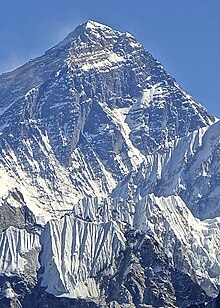
A key aspect of the success of the climb was the scaling of the cliffs of the Rock Band at about 8,200 metres (27,000 ft) by Nick Estcourt and Tut Braithwaite.
Bonington's route was climbed alpine style over a decade later in the 1988 Czechoslovak - New Zealand Mount Everest Southwest Face Expedition.
At Clogwyn Du'r Arddu in Wales numerous routes of a very high standard were achieved using strictly free climbing techniques.
His role as climbing photo-journalist on the "Eiger direttissima" in 1966 brought attracted attention and he was encouraged to mount his own expedition.
In very poor weather Bonington's expedition failed to reach the summit but the team gained a great deal of experience, in particular discovering that the line they had chosen above Camp 6 was not as favourable as they had anticipated.
Partly on account of the political situation in Tibet, Nepal started allowing climbers entry in 1950 although it closed its frontiers again in 1966.
[9][note 4] Nepal again allowed entry to climbers in 1969 and the Southwest Face, the only face accessible from Nepal, was such an attractive objective that Japan immediately mounted a spring reconnaissance in that year and returned in the autumn with a larger party with several climbers reaching 8,000 metres (26,000 ft) on a line striking left from the central gully (black—cyan route on the diagram below).
The face party had failed in much the same way as the British had the year before but the South Col team had managed what turned out to be a very significant achievement.
To get into a position to do this a large support team would need to make a rapid ascent up the central gully so very careful logistical planning would be necessary.
[20][21] Peter Boardman was later to remark "for a mountaineer, surely a Bonington Everest expedition is one of the last great Imperial experiences life can offer.
Hamish MacInnes was to be deputy leader and Dougal Haston, Doug Scott, Mick Burke, Nick Estcourt, Mike Thompson and Martin Boysen agreed to take part.
People joining the team for the first time were Peter Boardman, Paul ("Tut") Braithwaite, Ronnie Richards, Dave Clarke, Allen Fyffe and Mike Rhodes.
[34][note 7] Bonington's party reached Khunde on 14 August after a two-week trek and at Thyangboche they met the lama to receive his blessing.
[39] The plan was to attempt the route originally taken by the Japanese 1969 expedition, crossing the Rock Band via a deep gully to the left.
Scott and Burke started climbing the Southwest Face on 6 September, setting fixed rope to be used subsequently, and ascending 370 metres (1,200 ft) to the foot of a buttress at the place selected for Camp 3.
[42] Boysen and Boardman, and subsequently Haston, MacInnes and Bonington arrived to hack away platforms for camps suitable for sherpas and equipment high on the face.
It would take Haston two days to ascend from the foot of the face during which time Estcourt and Braithwaite would attempt to set fixed ropes up the gully.
They were climbing at 8,200 metres (27,000 ft), weighed down with oxygen cylinders, towards the gully with very few places that would take pitons but eventually they reached a snow patch suitable for a deadman anchor.
The first would be Scott and Haston (as had been widely expected); the second would be Burke, Boardman, Boysen and Pertemba; and the third Braithwaite, Estcourt, Ang Phurba and Bonington himself.
Burke had been climbing slowly but Bonington considered that this could have been due to the weight of camera equipment and he realised the value of having filming high up on the mountain.
[51] Haston, Scott and Ang Phurba left Camp 5 next morning, followed slightly later by six climbers (including Bonington) and sherpas in support.
Scott was impressed by the difficulty of the climb up the gully and he went on to lead while laying 76 metres (250 ft) more rope to the upper snowfield, the site for Camp 6.
[57][58][59][note 11] In gathering darkness they descended, abseiling down the Hillary Step, but by the South Summit, clouds were covering the sky and lightning was flickering so they prepared for the highest bivouac ever undertaken at that time.
[72][68] Boardman had frostbite in his feet, Pertemba was snowblind and Boysen got frostbitten hands clearing snow for the 30 hours they were trapped at Camp 6 by the storm.
Barclays, the sponsors, owned several media rights including those to the book Bonington was to publish, Everest the Hard Way, which became a best-seller and so the bank was able to recover its entire expenditure.
[22] Two years later Scott was proposing a lightweight expedition to The Ogre in the Karakoram that was to include Bonington (as a team member) and Haston.
[84] The Southwest Face was climbed by a Slovak expedition in 1988 when four climbers reached the South Summit in alpine style with no supplementary oxygen.
Jozef Just [sk] went on to reach the main summit on 17 October but on the descent his team all disappeared in a strong storm after their last radio contact with the base saying they were on the way to the South Col. Their bodies were never found.
[88][86] Forty years after the ascent ten of the expedition's members took part in a reunion meeting at the Royal Geographical Society in London, raising funds for Community Action Nepal.