1979 Imperial Valley earthquake
The 1979 Imperial Valley earthquake occurred at 16:16 Pacific Daylight Time (23:16 UTC) on 15 October just south of the Mexico–United States border.
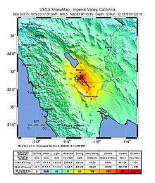
The area was equipped with an array of strong motion seismographs for analyzing the fault mechanisms of nearby earthquakes and seismic characteristics of the sediments in the valley.
[14] Damage to the roadways was heavier farther north on California State Route 86 where settling of the road by as much as four to six inches occurred, and a bridge separation closed the highway west of Brawley.
Governor Jerry Brown ended a presidential campaign trip through New England early in order to return to the Imperial Valley and declare a state of emergency there.
Water flow was immediately reduced to prevent further damage and to allow assessments to be made, and within four days the repairs had been completed and full capacity restored.
The decision to equip the building with nine strong motion sensors in May 1976 was based on its size, structural attributes, and location in a seismically active area.
The initial configuration was tested shortly after its installation when a relatively small (4.9 local magnitude) earthquake occurred 32 km (20 mi) northwest of the building on 4 November 1976.
The full 16-channel system was managed by the California Division of Mines and Geology Office of Ground Motion Studies and provided almost 60 seconds' worth of high resolution data during the 1979 event.
These differences in strength allowed damage to be concentrated in one or more areas rather than being distributed equally and reduced the building's ability to sustain the tremors.
[19]While the most extreme demonstration of the earthquake's intensity was at the Imperial County Services Building, the shock was felt over an area of roughly 128,000 square miles.
At numerous department stores and the fire station in Brawley, a collapsed brick wall, cracked concrete fixtures, and ceiling or roof damage was consistent with intensity VII shaking.
[20] An early study of the event encompassed more than 2,000 aftershocks (and included four of magnitude 5.0 or greater) that were recorded within 20 days of the mainshock, with the area south of the border near the epicenter remaining relatively quiet.
Another line of aftershocks along the projection of the southern San Andreas fault extended south into the valley up to 50 km (31 mi).
[21] During two outings in late 1979 and early 1980 several researchers (including Thomas H. Heaton and John G. Anderson) examined the region near the New River and discovered ground disturbances that were related to the Brawley aftershock.
At the Imperial County Dump, several instances of ground failure were observed in sedimentary deposits near the top of and parallel to the river bank, and other cracks were found in that area that were determined to be the result of differential settling.
A large pond had apparently formed near the KROP radio station's antenna site where profound liquefaction and subsidence occurred in the river valley.