2013 El Reno tornado
Remaining over mostly open terrain, the tornado did not impact many structures; however, measurements from mobile weather radars revealed extreme winds in excess of 313 mph (504 km/h)[1] within the vortex.
[5] Although the tornado remained over mostly open terrain, dozens of storm chasers unaware of its immense size and erratic movement were caught off-guard.
Near U.S. 81, TWISTEX scientist and engineer Tim Samaras, along with his son Paul and research partner Carl Young, died in the tornado.
With a broad influence of moderately strong cyclonic flow aloft, the air mass was expected to become unstable across much of the southern Great Plains, through the Upper Midwest and Mississippi Valley, by the afternoon.
[11] These factors, along with CAPE values in excess of 4000 J/kg and an embedded speed maxima rotating around the southern periphery of the low, made the threat of significant severe thunderstorms increasingly likely.
[11] The most intense severe weather activity was expected across the southern Great Plains, specifically central and eastern Oklahoma, during the afternoon hours.
As such, the Storm Prediction Center (SPC) issued a moderate risk of severe thunderstorms during the early morning hours of May 31 from southeastern Missouri to southwestern Oklahoma.
[11] At 3:30 p.m. Central Daylight Time (CDT) early that afternoon, the SPC issued a Particularly Dangerous Situation Tornado Watch from southwestern through northeastern Oklahoma, surrounding the Interstate 44 corridor.
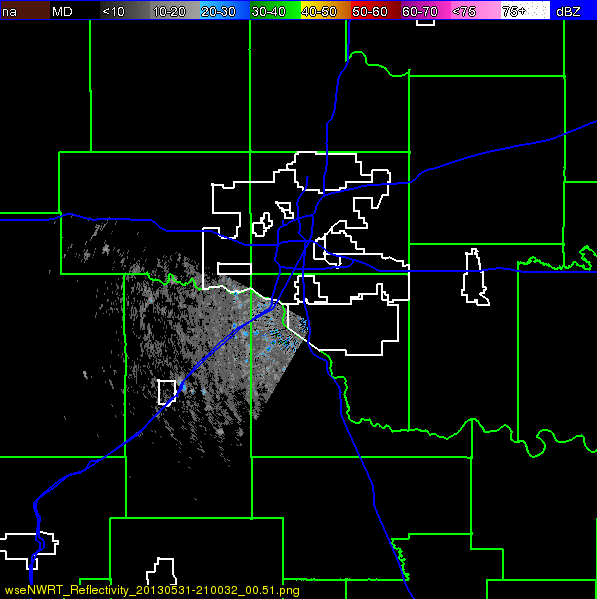
[13][14][15] A quasi-linear complex of thunderstorms began developing near the Highway 81 corridor west of Oklahoma City between 4:00 and 4:45 p.m. CDT, and rapidly reached severe intensity.
The University of Oklahoma's RaXPol mobile Doppler weather radar, positioned at a nearby overpass, measured winds preliminarily analyzed as in excess of 296 mph (476 km/h).
The two most intense vortices occurred north and east of the intersection of 10th Street and Radio Road, about 3 miles (4.8 km) southeast of El Reno.
Keli Pirtle, a Public Affairs worker at the National Oceanic and Atmospheric Administration, stated that, "despite the radar-measured wind speeds, the survey team did not find damage that would support a rating higher than EF3.
While the wind measurements from the mobile radars are considered reliable, NWS policy for determining EF-ratings is based on surveys of ground damage.
[30][31] The tornado's unusual behavior consisted of these simultaneous occurrences: abrupt changes in direction, rapid enlargement to a width of 2.6 mi (4.2 km) in diameter in about 30 seconds, swift increase in forward motion from about 20 to 55 mph (32 to 89 km/h) within a few minutes, multiple vortices within and around, and an expansive translucent outer circulation without a full condensation funnel while being surrounded and obscured by precipitation made it a worst-case scenario for storm chasers.
Chasers can generally get a clear view of the tornado from that area; however, it places them at great risk and with little time to react should the storm take a left turn.
[34] Normally, Tim drove a reinforced three-quarter ton truck optimized for hail protection and stability in high winds; however, Carl was driving an unmodified Chevrolet Cobalt, a subcompact vehicle with three 45-lb barometric probes in the trunk likened by one TWISTEX chaser to a "pizza delivery car", making it much less suited to high winds and rain-slicked backcountry dirt roads.
[39] University of Oklahoma student Billy Prater, along with his father and a friend, sought refuge under an overpass (an action strongly discouraged in these situations) when the tornado changed direction.
[40] Near Union City, debris from a barn destroyed by the tornado struck the vehicle of Brandon Sullivan and Brett Wright, breaking their windshield; they escaped without injury.
He escaped a few hundred meters ahead of the TWISTEX crew on Reuter Road and is believed to be the last person to see the car occupied by Samaras, his son Paul and Young.
Entering the larger tornadic circulation without the ability to maintain situational awareness of the internal sub-vortex was likely a key contributing factor to the deaths and injuries.
AccuWeather Senior Vice President Mike Smith urged against overreacting to their deaths, citing that they were the first chasers to be killed in 40 years of the practice and that chasing as a whole is a significant source of real-time and research information.
The chaser information is compiled with radar and lightning data and the project is intended to eventually expand to a standardized open access database covering future events.
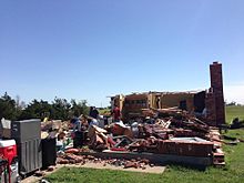
[52] Several large metal electrical transmission poles were downed, trees were snapped and defoliated, and multiple vehicles were tossed from roadways in the area.
"[60] It has been suggested that the evacuation was partially caused by a controversial call to action on-air by KFOR-TV chief meteorologist Mike Morgan, who suggested on-air during coverage of the storm – as the tornado was projected to track into Oklahoma City – that residents without underground storm shelters or safe rooms get into their cars and evacuate south of the track.
[62] Dr. Jeff Masters of Weather Underground stated that had the tornado tracked directly over one of the congested highways, the death toll could have easily exceeded 500.

