Tornado outbreak of November 17, 2013
In addition to tornadoes, the system associated with the outbreak produced sizeable hail peaking at 4.00 in (10.2 cm) in diameter in Bloomington, Illinois, as well as damaging winds estimated as strong as 100 mph (160 km/h) in three locations.
The first storms associated with the event formed during the afternoon and evening hours of November 16 over the Great Plains, primarily producing hail and strong winds.
However, tornadic activity was limited to November 17, as individual supercell thunderstorms tracked across the Midwest United States, at times producing long-tracked tornadoes.
In addition to structural damage, widespread power outages affected thousands of electricity customers across the same regions impacted by the tornado outbreak and subsequent squall line.
[7] As models gained a better consensus, the SPC later anticipated substantial increase in atmospheric instability along the periphery of a potential cold front, indicating the risk of damaging wind gusts and tornadoes.
[8] Additional confidence over the next 24 hours resulted in a substantial expanding of this risk area into the lower Great Lakes on November 14, valid for Day 4.
The overlap of increasing moisture in the atmosphere, wind shear, and high levels of CAPE were expected to contribute to the potential severe weather.
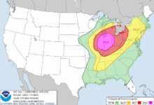
[11] On November 16 at around 0700 UTC, the SPC upgraded their maximum convective outlook for the following day to a "moderate" for areas of the Ohio River Valley and the Great Lakes region on the basis of destabilizing atmospheric conditions, favorable wind shear, and an approaching shortwave trough.
[12] The outlook was maintained for the 1730 UTC Day 2 update on November 16, but was also expanded to the west and a mention of the risk for strong tornadoes was added to the discussion.
[13] With development assisted by a dry line,[14] the storms did not produce any tornadoes, but caused strong winds in hail as large as softballs in northeastern Kansas.
[15] The threat of additional severe activity that day was mitigated by cooling surface temperatures and marginal moisture and instability in the lower atmosphere.
[16] By the end of the day, convection had moved closer to the Mississippi River, with the focus of intensifying storm activity shifting southeastwards to areas in and around the Ozark Plateau.
Model data indicated the weakening of the capping inversion coinciding with increasing instability and wind shear, which would lead to the enhanced potential for storms and tornadoes as the night progressed and the low-level jet strengthened.
The issuance of a high-risk zone reflected the anticipation of an intense upper-level trough and a strong mid-level jet stream producing highly conducive conditions for the development and prolonging of severe weather.
[19] The first signs of convection associated with the broad weather system began to form around dawn on November 17 over portions of Illinois, Iowa, and Missouri, triggered by a propagating cold front.
[22] Throughout the morning, discrete supercell thunderstorms developed ahead of the cold front across the length of Illinois;[23] their expected persistence eastward prompted the SPC to issue a second PDS tornado watch at 1621 UTC, this time for areas of Indiana, Michigan, and Ohio.
As intense storm cells propagated across Illinois and Indiana, strong low-level wind shear in the vicinity of a warm front coupled with the weather system made areas as far north as Northern Michigan a viable environment for tornado development.
Despite the change in storm mode, additional strong tornadoes still occurred as far east as Western Ohio due to circulations embedded in the squall line.
[35] Forced along the extent of a cold front,[36] the primary squall line raced eastward across Ohio at approximately 60 mph (97 km/h), reaching Pennsylvania by 0200 UTC.
[155] The tornado initially touched down at 16:59 UTC roughly 2.4 mi (3.9 km) southeast of East Peoria in Tazewell County before moving directly into town.
The tornado then strengthened and broadened to its peak intensity as a high-end EF4 with winds estimated at 190 mph (310 km/h) and a damage width extending 0.5 mi (0.80 km) in diameter as it moved into the nearby town of Washington.
[27] The tornado then moved into Woodford County, where it maintained its size but slightly weakened to EF3 intensity as it passed near the towns of Roanoke, Benson, and Minonk.
[161][162] The tornado rapidly intensified as it tracked northeastward, striking a small farm at mid-range EF4 intensity with maximum winds estimated to have been 180 mph (290 km/h).
[160][161][162] By 18:07 UTC, the tornado continued through rural areas towards New Minden at EF2 strength, snapping power poles, destroying outbuildings, and removing much of the roof from a site-built home and a garage.
[163] The final killer tornado of the outbreak was a long-tracked, heavily rain-wrapped EF3 that moved along the Ohio River through parts of Kentucky and Illinois and devastated the small town of Brookport, along with nearby rural communities.
[164][106] The tornado initially touched down just inside western McCracken County, Kentucky northeast of Kevil and moved across the northern fringes of Paducah.
The tornado crossed the Ohio River into Massac County, Illinois where it went through Brookport at low-end EF3 strength and completely destroyed dozens of mobile homes, many of which were blown over 100 feet (30 m).
The tornado caused some minor damage to guard rails on the Ohio River bridge that carries traffic from Paducah to Brookport on U.S. Highway 45.
[166] Much of Ohio was affected by straight-line winds, which caused widespread tree damage and sparked a power outage which impacted thousands of electricity customers.