2014 Oso landslide
A major landslide occurred 4 miles (6.4 km) east of Oso, Washington, United States, on March 22, 2014, at 10:37 a.m. local time.
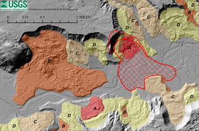
A portion of an unstable hill collapsed, sending mud and debris to the south across the North Fork of the Stillaguamish River, engulfing a rural neighborhood, and covering an area of approximately 1 square mile (2.6 km2).
[6][7] The March 2014 landslide engulfed 49 homes and other structures in an unincorporated neighborhood known as "Steelhead Haven" on the south side of the North Fork of the Stillaguamish River, approximately 4 miles (6.4 km) east of Oso, Washington.
[15] The slide, described by witnesses as a "fast-moving wall of mud", contained trees and other debris; it cut through homes directly beneath the hill on the south side of the Stillaguamish River.
While the landslide was well documented, a research team from the Geotechnical Extreme Events Reconnaissance (GEER) announced in April 2014 that it would investigate the factors contributing to the slide.
[20] Late in the evening of March 22, 2014, Washington's Lieutenant Governor Brad Owen declared a state of emergency in Snohomish County.
Washington state Governor Jay Inslee toured the area by air the following day before joining county officials at a news conference.
On April 2, 2014, with the river flowing in a new channel at the north end of the debris dam, the service lifted the flash flood watch.
[28] Four days later, during passage of the Green Mountain Lookout Heritage Protection Act, Senator Patty Murray (D-WA) mentioned the landslide, saying the bill would "provide a glimmer of hope for the long-term recovery of this area.
There, he was joined by Governor Inslee and Senators Patty Murray and Maria Cantwell as well as Rep. Suzan DelBene for a flyover of the slide and debris field.
After viewing the site, the president met privately with survivors, families of the victims, and some of the scene's first responders and rescuers at the Oso fire hall.
[37][38] Grandy Lake Forest Associates of Mount Vernon, Washington[39] proposed a 15-acre (6 ha) clearcut at the upper edge of the Oso landslide zone in 2004.
[40] An investigation is being conducted to determine whether Grandy Lake crossed into the restricted area that could theoretically feed groundwater into the landslide zone, affecting it for 16 to 27 years.
The tribute is set to be built at the location of the slide and fundraising efforts are underway with wood from the formerly standing memorial tree to be repurposed and used for the permanent display.
[47][46] Ground vibrations generated by the Oso landslide were recorded at several regional stations and subsequently analyzed by the Pacific Northwest Seismic Network (PNSN).
[49] In the days following the slide, Snohomish County Emergency Management Director John Pennington speculated a 1.1 magnitude earthquake on March 10 may have triggered the landslide.
[52] The landslide occurred at the southeastern edge of Whitman Bench, a land terrace about 800 ft (240 m) above the valley floor and consisting of gravel and sand deposited during the most recent glaciation.
Sand and gravel carried by the flow and entering the glacial lake dropped out to form a delta, the remnant of which is now known as Whitman Bench.
[55] Following the glacier's retreat and allowing for the lake to be released, the river carved out most of the clay and silt deposits, leaving the former delta "hanging" approximately 650 ft (200 m) above the current valley floor[56] When the sand portion of a deposit has very little clay or "fines" to cement it together, it is structurally weak, leaving the area around it vulnerable.
[59] According to a 1999 report submitted to the United States Army Corps of Engineers[60] by geologist Daniel J. Miller, PhD:[61] The Hazel landslide has been active for over half a century.
Thorsen (1996) noted a tight river bend impinging on the north bank with active landslides visible in 1937 aerial photographs.