2016 Katie tornado
As it continued to track alongside East 1690 Road, it rapidly strengthened to EF2 intensity, where multiple tree trunks were found to be snapped.
[5][1] The tornado then crossed the Wildhorse Creek Reservoir, causing an unknown amount of damage to trees or other structures.
It continued tracking through relatively unpopulated areas of southern Katie, only hitting the far-south portions of North 3190 Road.
[5] The tornado tracked through another forest, before striking the southern portions of North 3220 Road.and the Wildhorse Creek Site 59 Reservoir.
It then briefly moved sharply to the south before tracking back up to the northeast, and then began to straighten out its path eastward.
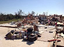
The tornado reached EF3 intensity for a final time on North Private 3246 Drive, where two separate homes were destroyed with their foundations left exposed.
A manufactured home located off of East County Road 1680 slid off of its foundation in 87 mph winds caused by the tornado.
In a post-tornado survey, the National Weather Service took an estimated 40 photos of the damage,[11] and storm chaser Reed Timmer shot a drone video documenting the path of the tornado.
Although the tornado retained mainly EF1-EF3 intensity, it did produce a pocket of EF4 damage to a home that was destroyed, and its foundation was left exposed and swept clean of debris.