2020 Nashville tornado
The Storm Prediction Center (SPC) first issued a slight risk across northeastern Arkansas into the Tennessee Valley area in their 1:00 a.m. CST (06:00 UTC) March 2 outlook.
In their forecast, the SPC noted that an unstable atmosphere was likely to materialize ahead of an approaching cold front, but that this environment would likely be contained by a capping inversion for most of the day.
[4] The tornado first touched down around 12:32 a.m. CST (06:32 UTC) in western Davidson County along River Road, 7 miles (11 km) northeast of Pegram.
The tornado crossed the river a second time before heavily damaging the John C. Tune Airport and an industrial area along Centennial Boulevard,[9][10][11] including a terminal and the headquarters of Western Express, Inc. at high-end EF2 strength.
More than 90 aircraft parked at the airport, including charter jets, smaller airplanes, and a news helicopter operated by CBS affiliate WTVF were destroyed.
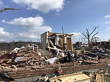
[14][15][16] Maintaining high-end EF2 strength, it crossed Briley Parkway and struck the former Tennessee State Prison,[17][18][19] which sustained considerable structural damage.
[29] The tornado grew to nearly two-thirds of a mile (1.1 km) wide as it crossed Interstate 65 and moved into Germantown, just north of the Tennessee State Capitol, where it produced a widespread swath of mid to high-end EF2 damage.
This section of the track was similar to the path of the F3 tornado that struck parts of Downtown Nashville on April 16, 1998, which also narrowly missed the WTVF building.
After crossing the Cumberland River for the fifth time along the Jefferson Street Bridge,[35][36][37] the tornado struck Topgolf and an industrial area, causing damage at EF1 to EF2 intensity.
[43][44][45] The tornado crossed Lebanon Pike and then the Stones River a third time and continued into the southern part of Hermitage at high-end EF2 intensity.
Numerous homes and industrial buildings sustained severe damage in Hermitage, along with Dodson Chapel United Methodist Church, in the area of Central Pike, Old Hickory Boulevard, and Tulip Grove Road.
Kroger, Panera Bread, and Petco, in addition to multiple apartment buildings, sustained considerable damage along Old Hickory Boulevard.
Maintaining EF3 intensity along a six-mile (9.7 km) swath, the tornado continued east of Mount Juliet along the north side of Interstate 40 towards Lebanon, causing severe damage in residential, commercial, and industrial areas between the two cities.
Two metal truss electrical transmission towers were blown over near Tuckers Gap Road before the tornado weakened to high-end EF1 strength and entered Lebanon.
As the tornado passed Linwood Road, a gas station and a heavy equipment auctioneer's property sustained low-end EF2 damage.
More tree and structural damage was observed as the tornado left Gordonsville at EF1 intensity before it lifted east-northeast of Hickman along Lancaster Highway at 1:35 a.m. CST (07:35 UTC).
Engineers found that tornadic winds blew the western windows of the building inward, buckling the concrete masonry unit (CMU) walls and causing the roof to partially collapse downward.

EF1 86–110 mph
EF2 111–135 mph
EF3 136–165 mph

EF1 86–110 mph
