Hurricane Isaias
Isaias strengthened into a Category 1 hurricane on the next day, reaching an initial peak of 85 mph (140 km/h), with a minimum central pressure of 987 mbar (hPa; 29.15 inHg).
Devastating flooding and wind damage were reported in Puerto Rico and the Dominican Republic, with many towns without electricity or drinking water.
[6] Isaias was one of several destructive 2020 hurricanes whose names were not retired by the World Meteorological Organization following the season, along with: Sally, Delta, and Zeta.
[7][8][9] The National Hurricane Center (NHC) first began tracking a vigorous tropical wave off the west coast of Africa on July 23.
Contrary to predictions by meteorologists, the mountainous terrain of Hispaniola did not weaken the storm as the system had a broad circulation and developed a new low-pressure center to the north of the island, allowing Isaias to maintain its intensity.
[3] Moderate to strong southwesterly wind shear and dry air entrainment began affecting the storm a few hours later, resulting in the low-level circulation center (LLCC) being exposed near the western edge of the convection.
After a brief weakening trend, Isaias began to intensify again, with deep convection firing over the exposed center and an eye feature forming, as seen on Bahamian radar.
Later that evening, data from another hurricane hunter reconnaissance aircraft confirmed a closed eyewall and a lower minimal central pressure of 987 mbar (29.1 inHg).
[16] At 15:00 UTC on August 1, Isaias made landfall on Northern Andros Island, Bahamas with sustained winds of 80 mph (130 km/h), slightly weaker than its peak.
The storm began to quickly reintensify, regaining hurricane status at 18:00 UTC on August 3, before reaching its peak intensity, with 1-minute sustained winds of 90 mph (140 km/h) and a minimum central pressure of 986 mbar (29.1 inHg).
In the end, a total of 109 tornado warnings were issued by various National Weather Service offices across a swath of 12 states due to Hurricane Isaias.
[63] On August 2, in a press call with reporters, New York governor Andrew Cuomo said, in conjunction with a press release by New York City Emergency Management, that models showed Isaias hitting the NYC and Long Island area with sustained winds of 50 to 65 miles per hour (80 to 105 km/h) and 3 to 6 inches (75 to 150 mm) of rain by Tuesday August 4.
[80] A woman was dragged by a river in Rincón, Puerto Rico while she was crossing a bridge due to heavy rain; she was found dead two days later.
[81][82] Jayuya, a town in the center of Puerto Rico experienced substantial effects including the loss of its 1.5 million dollar hot air balloon, an important tourist attraction.
[83] Due to the extensive damage, President Donald Trump approved an emergency declaration request from Puerto Rico's governor Wanda Vázquez Garced.
[3] Across the Mid-Atlantic states, Isaias was influenced by an approaching cold front, which enhanced wind shear and created conditions favorable for tornadoes.
[3] The outer rainbands of Isaias began to impact the Florida Peninsula on August 1, bringing gusty winds, heavy rainfall, and flooding to the area.
[101][102] Heavy damage was inflicted to multiple homes in Oak Island and Ocean Isle Beach, North Carolina, including three that were destroyed in the latter community by a large fire.
[103] Trees and power lines were knocked down in Myrtle Grove, North Carolina, by the rapidly-forming northern eyewall as the storm came ashore.
The tornado then continued northwestward and weakened slightly to EF2 intensity, flattening a large swath of trees and causing significant damage to some homes in neighborhoods along or just off of Woodward Road.
After the storm, North Carolina Governor Roy Cooper, toured the mobile home park hit by the tornado in Windsor, saying it was "devastating" to see what happened to the area.
[3] An EF2 near Courtland damaged numerous homes and businesses along US 58, including a hotel, which sustained total roof loss and collapse of multiple second-story exterior walls.
A camper and a number of outbuildings were overturned and tossed, and several homes on the edge of the path had partial roof loss and blown out windows.
The tornado then nearly paralleled US 13 and DE 1 through the eastern side of Townsend at high-end EF1 strength, causing considerable damage to homes and businesses.
The tornado then reached low-end EF2 intensity as it struck Middletown, where many homes near Spring Hollow Drive sustained significant roof, exterior wall, and garage door damage.
Farther along the path, the tornado maintained low-end EF2 intensity as it tracked near Lums Pond and through portions of Bear, where more homes were damaged, and trees were downed.
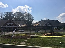
The tornado then struck the Children's Village Day Care center, causing significant damage as large portions of roof structure were torn from the building.
[2] In New Jersey, the storm spawned a tornado that brought winds as high as 109 mph (175 km/h) just off the coast in Long Beach Island, as well as heavy rainfall up to 5.41 in (137 mm) causing numerous power outages.
[178] A man in River Vale, New Jersey was killed after possibly being electrocuted from downed wires, while doing yard work to clean up from the storm.
[210] Thousands of customers throughout the Tri-State (NY-NJ-CT) area remained without power for over a week after the storm, with Governor Cuomo and the New York State Legislature launching an investigation into different utility companies' respective responses.

Tropical storm (39–73 mph, 63–118 km/h)
Category 1 (74–95 mph, 119–153 km/h)
Category 2 (96–110 mph, 154–177 km/h)
Category 3 (111–129 mph, 178–208 km/h)
Category 4 (130–156 mph, 209–251 km/h)
Category 5 (≥157 mph, ≥252 km/h)
Unknown