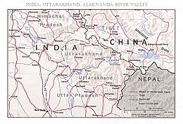
2021 Uttarakhand flood
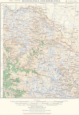
[11] According to an article in Scientific American, 12 February 2021, data from Planet Labs was interpreted by Dan Shugar, a geomorphologist at the University of Calgary, to suggest that a hanging glacier "15 football fields long and five across" had separated from a mountain and plummeted into the Ronti Gad, a tributary of the Rishiganga (Map 3, 30° 28' N, 79° 45' E; Map 2, lowest left-bank tributary).
[12] According to BBC News, four scientists from the Wadia Institute of Himalayan Geology, Dehradun, India flew over the site in a helicopter, took photographs, and gathered other data; they consider the hanging glacier that cracked and plunged into the Rishiganga basin, to have been attached to a subsidiary peak, Raunthi, 5,600 m (18,372 ft), just below Nanda Ghunti (Map 3, Ronti, at the intersection of 81 and 423).
[13] According to Dr. Kalachand Sain, director of the Wadia Institute, climate change is the major factor in the rapid freezing and thawing of ice that causes glacier fractures.
The glacier ice turned into water over the course of the 3.2 km elevation difference from the peak, which further worsened the impact by causing a debris flood wave.
[5] Among the places most severely hit by the floods are Joshimath, Rini, Nanda Devi National Park, Tapovan Vishnugad Hydropower Plant and Sridhar.
[25] Many villages were evacuated as authorities emptied two dams farther down the river to stop the floodwaters from reaching towns of Haridwar and Rishikesh.
In the aftermath of the floods, residents in Joshimath began noticing cracks in homes; eventually over 600 houses were evacuated after a local temple collapsed.
[29] According to another committee led by Dr. Chopra and appointed by India's Supreme Court in 2020, per the New York Times, the Government of India had built 500 miles (800 km) of highway—much 33 feet (10 m) wide—in the hills of Uttarakhand in order to improve approaches to Hindu temples in the high Himalayas, overriding the advice of its own experts,[31] The headman of Reni, the village most adversely affected by the flood, stated that the village residents feared that the blasting of the rocks during the hydropower dam's construction would bring on dangerous landslides.