A3 (Croatia)
The motorway connects Zagreb, the nation's capital, to the historical Slavonia region of Croatia and a number of cities along the Sava River.
Construction of the entire route was completed in 2006; further development entails new exits, new rest areas and the reconstruction of the existing motorway.
[6] The construction cost of the A3 motorway is estimated at 7 billion Croatian kuna (approximately 958.9 million euro).
It represents the shortest and the most comfortable transit traffic route between Slovenia, northern Italy, Austria, Switzerland, and southern Germany to the west; and Serbia, Bosnia and Herzegovina, Bulgaria, North Macedonia, Greece, and Turkey to the east.
[12] The route serves Sisak via the D36; Banja Luka, Bosnia and Herzegovina via the D5 and Stara Gradiška border crossing; Osijek via the A5; and Vinkovci via the D55.
As of September 2010, the motorway has 21 interchanges, providing access to numerous towns and cities and the Croatian state road network.
The system comprises variable traffic signs used to communicate changing driving conditions, possible restrictions and other information to motorway users.
[15] There are numerous rest areas along the motorway, providing various types of services ranging from simple parking spaces and restrooms to filling stations, restaurants and motels.
[4][17] The route between Bobovica and Ivanja Reka interchanges (inclusive) serves as a part of Zagreb bypass, and it is therefore not tolled.
[18] The A3 section of Zagreb bypass is currently the busiest section of the Croatian motorway network, with annual average daily traffic (AADT) volume exceeding 40,000 vehicles, leading to congestion of the six-lane bypass at peak hours, especially during the summer, when tourist traffic adds to the congestion.
Despite being a shorter and a more direct route, those avenues are much more congested than the bypass at rush hours and they contain at-grade intersections and traffic lights at some of their junctions.
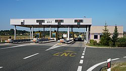
[23] Summertime and holiday queues at the Ivanja Reka mainline toll plaza can be considerable, a problem exacerbated during the usual weekend-to-weekend tourist stays at Croatia's coastal resorts.
[19] In such conditions, motorway users are advised to use the Rugvica and Ivanić Grad exits ahead of the Ivanja Reka interchange to avoid the queues.
[24] A modern highway connecting Zagreb and Belgrade was originally designed in the late 1940s, and construction began on April 1, 1948.
The 382-kilometre (237 mi) road spanning the two cities, called Brotherhood and Unity Highway before the 1990s, was completed and officially opened on July 27, 1950.
In 1971, as the road gradually became congested, the plans to build the motorway on the route were approved by the Parliament of the Socialist Republic of Croatia.
Unlike the remainder of the motorway, which was constructed by widening the existing road and adding the additional carriageway, these two sections were built entirely from scratch.
In October 1991, a part of the motorway between Novska and Nova Gradiška became inaccessible to the government of the Republic of Croatia due to military occupation of the area by the forces of the so-called SAO Western Slavonia.
The motorway pavement was seriously deteriorated, as evidenced by extensive ruts and cracks incurred during the four-year wartime period.
Unlike repairs made to the viaducts and flyovers, mine clearance and pavement reconstruction took considerably more time to perform.
The Sveta Klara interchange is planned to provide another connection to the city of Zagreb (via Većeslava Holjevca Avenue).
[42][43][44] Finally, the Andautonija rest area is planned for the A3 section of the Zagreb bypass between the Jakuševec and Kosnica interchanges.
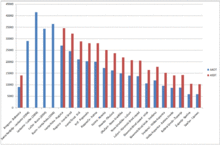
The reported traffic volume gradually decreases as the motorway chainage increases and as it passes by various major destinations and the interchanges that serve them.
The busiest tolled section of the motorway is Ivanja Reka–Rugvica with 27,049 AADT and 34,543 vehicle average summer daily traffic (ASDT) figures.
The traffic volume gradually decreases from that section eastward to the eastern terminus of the motorway, where the lowest AADT and ASDT figures are recorded.
Even though the rest areas found along the A3 motorway generally follow this ranking system, there are considerable variations, as some of them offer extra services.