A6 (Croatia)
[2] The motorway forms a major north–south transportation corridor in Croatia and is a part of European route E65 Nagykanizsa–Zagreb–Rijeka–Zadar–Split–Dubrovnik–Podgorica.
[3] The A6 motorway runs near a number of Croatian cities, provides access to Risnjak National Park and indirectly to numerous resorts, notably in the Istria and Kvarner Gulf regions.
The motorway is nationally significant because of its positive economic impact on the cities and towns it connects, and because of its contribution to tourism in Croatia.
Sections of the motorway that have a gradient greater than 4% are divided into three lanes to prevent traffic problems caused by slower vehicles.
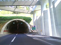
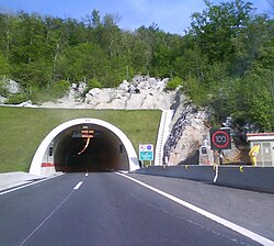
As the route traverses rugged mountains it requires numerous long bridges, viaducts, tunnels, and other structures.
[8] The majority of the motorway is a ticket system toll road with pricing tied to vehicle classification.
[11] After the Croatian War of Independence, efforts to build the motorway were renewed and construction resumed in 1996.
Because of the link formed between Zagreb and Rijeka, tourism-related traffic originating from the countries neighbouring Croatia to the north flows via this road to the Adriatic coast on the south.
The route is complete and further development of the motorway includes only the construction of additional rest areas.
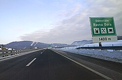
There are a number of rest areas along the motorway providing various types of services ranging from simple parking spaces and restrooms to filling stations, restaurants, and hotels.
[8][19] As of October 2010, the motorway has nine interchanges providing access to numerous towns and cities and the Croatian state road network.
The system comprises variable traffic signs used to communicate changing driving conditions, possible restrictions, and other information to motorway users.
[21] The A6 motorway mainly runs through the mountainous Gorski Kotar region, requiring not only large bridges and viaducts and long tunnels along the route, but also special care must be paid to protection of the environment, as the route is located in karst terrain, with numerous water supply protection zones and significant natural heritage.
Due to the motorway access and its proximity to a number of seaside resorts, Risnjak is the most visited national park in Croatia.
[28] As the A6 motorway route runs through mountainous terrain of Gorski Kotar, it comprises a substantial number of major structures—bridges, viaducts, tunnels, underpasses, flyovers, and culverts.
In order to prevent abrupt changes in road conditions caused by the weather, the distance between the tunnels is covered by translucent roofing.
While the former, as with all the other tunnels mentioned, is significant due to its length, the latter is notable for the large cavern encountered during its excavation.
[11] The first section of the A6 motorway, between Orehovica and Kikovica, was 10.5 km (6.5 mi) long and opened on September 9, 1972.
The funds were instead allocated to the construction of a motorway that would travel between Ljubljana, Zagreb, Belgrade, and Skopje, then known as the Brotherhood and Unity Highway.
[11] The sole exception to the 25-year-long hiatus was the 7.25-kilometre (4.50 mi) long Kikovica–Oštrovica section, which was originally executed as an expressway and opened in 1982.
[10][38] In 1996, construction of the A6 motorway resumed, and in 1997, a further 30 km (19 mi) of expressway between Oštrovica and Kupjak was completed.
In December 1997, the government of the Republic of Croatia founded the Autocesta Rijeka–Zagreb company and tasked it with operating the completed sections of motorway and the construction of the remainder of the route.
[31][41] The upgraded motorway was officially opened on October 22, 2008, by Prime Minister Ivo Sanader at a ceremony held at the southern portal of Tuhobić Tunnel.
The reported traffic volume exhibits no significant variations as the motorway chainage increases, and as it passes by various major destinations and the interchanges that serve them, except at the Vrata interchange, where traffic to and from Krk Island, Crikvenica, and Novi Vinodolski flows.
[44] Substantial variations observed between AADT and ASDT are normally attributed to the fact that the motorway carries significant tourist traffic to Istria and Kvarner Gulf.
[45] Even though the rest areas found along the A6 motorway generally follow this ranking system, there are considerable variations, as some of them offer extra services.