Great Britain Historical GIS
The Great Britain Historical GIS (or GBHGIS) is a spatially enabled database that documents and visualises the changing human geography of the British Isles,[1] although is primarily focussed on the subdivisions of the United Kingdom mainly over the 200 years since the first census in 1801.
The first version of the GB Historical GIS was developed at Queen Mary, University of London between 1994 and 1999, although it was originally conceived simply as a mapping extension to the existing Labour Markets Database (LMDB).
The work was mainly funded by the UK National Lottery, so the results had to be useful to a far wider audience than most historical GIS projects.
However, they are mainly accessed via MapServer's implementation of the Open Geospatial Consortium's Web Map Service standard.
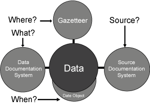
Britain has had an unusually large number of changes to its local government geography, and the current districts date back only to 1996, to 1974 or, in London, to 1965.
As census reporting has always been based on local government units, it is hard to study how any particular area has changed in the long term.
Components of the GB Historical GIS are available for download by academic researchers from the UK Data Archive and from EDINA's UKBorders system.
However, the main way most people can access the system is via the Vision of Britain web site, developed by the GB Historical GIS project with their lottery funding.