Latitude
In geography, latitude is a geographic coordinate that specifies the north-south position of a point on the surface of the Earth or another celestial body.
Latitude and longitude are used together as a coordinate pair to specify a location on the surface of the Earth.
The simplest choice for the reference surface is a sphere, but the geoid is more accurately modeled by an ellipsoid of revolution.
[1] Since there are many different reference ellipsoids, the precise latitude of a feature on the surface is not unique: this is stressed in the ISO standard which states that "without the full specification of the coordinate reference system, coordinates (that is latitude and longitude) are ambiguous at best and meaningless at worst".
This is of great importance in accurate applications, such as a Global Positioning System (GPS), but in common usage, where high accuracy is not required, the reference ellipsoid is not usually stated.
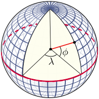
In English texts, the latitude angle, defined below, is usually denoted by the Greek lower-case letter phi (ϕ or φ).
For instance, The Needles lighthouse is at 50°39.734′ N 001°35.500′ W.[2] This article relates to coordinate systems for the Earth: it may be adapted to cover the Moon, planets and other celestial objects (planetographic latitude).
More precise measurement of latitude requires an understanding of the gravitational field of the Earth, either to set up theodolites or to determine GPS satellite orbits.
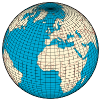
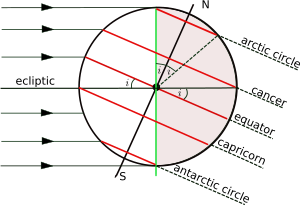
The plane through the centre of the Earth and perpendicular to the rotation axis intersects the surface at a great circle called the Equator.
\ In 1687 Isaac Newton published the Philosophiæ Naturalis Principia Mathematica, in which he proved that a rotating self-gravitating fluid body in equilibrium takes the form of an oblate ellipsoid.
In pre-satellite days they were devised to give a good fit to the geoid over the limited area of a survey but, with the advent of GPS, it has become natural to use reference ellipsoids (such as WGS84) with centre at the centre of mass of the Earth and minor axis aligned to the rotation axis of the Earth.
GPS handsets include software to carry out datum transformations which link WGS84 to the local reference ellipsoid with its associated grid.
For example, the defining values for the WGS84 ellipsoid, used by all GPS devices, are[4] from which are derived The difference between the semi-major and semi-minor axes is about 21 km (13 miles) and as fraction of the semi-major axis it equals the flattening; on a computer monitor the ellipsoid could be sized as 300 by 299 pixels.
The same coordinates on the datum ED50 define a point on the ground which is 140 metres (460 feet) distant from the tower.
[citation needed] A web search may produce several different values for the latitude of the tower; the reference ellipsoid is rarely specified.
The evaluation of the meridian distance integral is central to many studies in geodesy and map projection.
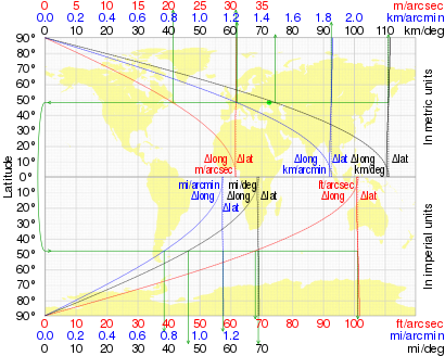
+ 0.5 degrees on the WGS84 spheroid is The variation of this distance with latitude (on WGS84) is shown in the table along with the length of a degree of longitude (east-west distance): A calculator for any latitude is provided by the U.S. Government's National Geospatial-Intelligence Agency (NGA).
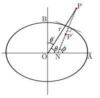
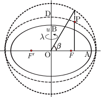
[7] The geocentric latitude is the angle between the equatorial plane and the radius from the centre to a point of interest.
Taking the value of the squared eccentricity as 0.0067 (it depends on the choice of ellipsoid) the maximum difference of
In terms of Cartesian coordinates p, the distance from the minor axis, and z, the distance above the equatorial plane, the equation of the ellipse is: The Cartesian coordinates of the point are parameterized by Cayley suggested the term parametric latitude because of the form of these equations.
The authalic latitude (after the Greek for "same area"), ξ, gives an equal-area projection to a sphere.
where and and the radius of the sphere is taken as An example of the use of the authalic latitude is the Albers equal-area conic projection.
The conformal latitude defines a transformation from the ellipsoid to a sphere of arbitrary radius such that the angle of intersection between any two lines on the ellipsoid is the same as the corresponding angle on the sphere (so that the shape of small elements is well preserved).
The conformal and geocentric latitudes are nearly indistinguishable, a fact that was exploited in the days of hand calculators to expedite the construction of map projections.
The geodetic coordinates P(ɸ,λ,h) are the latitude and longitude of the point N on the ellipsoid and the distance PN.
The relation of these different heights requires knowledge of the shape of the geoid and also the gravity field of the Earth.
These coordinates are the natural choice in models of the gravity field for a rotating ellipsoidal body.
[5] Astronomical latitude (Φ) is the angle between the equatorial plane and the true vertical direction at a point on the surface.
[5] Astronomic latitude is calculated from angles measured between the zenith and stars whose declination is accurately known.
The angle between the astronomic and geodetic normals is called vertical deflection and is usually a few seconds of arc but it is important in geodesy.


- Ocean
- Ellipsoid
- Local plumb line
- Continent
- Geoid