Great Britain road numbering scheme
While some of Great Britain's major roads form part of the international E-road network, no E-routes are signposted in the United Kingdom.
This scheme applies only to England, Scotland and Wales; a separate system using similar conventions is used in Northern Ireland, as well as outside the United Kingdom in the Isle of Man, Jersey and British Overseas Territories.
[2] As the Board needed to work out which roads should be funded, upgraded or replaced, its secretary, William Rees Jeffreys, appointed Henry Maybury, one of the Board's senior engineers, to devise a classification system and then assign numbers to the highways for identification purposes.
[citation needed] It did not resume until the Ministry of Transport was formed in 1919 and given authority to classify highways[4] and to allocate funding for road maintenance, authority for which was granted by section 17 (2) of the Ministry of Transport Act 1919.
[citation needed] A classification system was created in 1922,[5] under which important routes connecting large population centres, or for through traffic, were designated as Class I, and roads of lesser importance were designated as Class II.
The definitive list of those roads was published on 1 April 1923, following consultations with local authorities.
Originally, those numbers beginning in T were to be made public, but that was eventually deemed unnecessary.
The designated A1 later moved to the western bypass around the city, and roads between the two found themselves back in Zone 1.
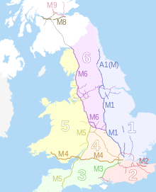
They were given an M prefix, and in England and Wales a numbering system of their own not coterminous with that of the A-road network, though based on the same principle of zones.
[citation needed] This numbering system was devised in 1958–59 by the then Ministry of Transport and Civil Aviation, and applied only in England and Wales.
As a result, there is no M7 (as no motorway follows the A7), and when the A90 was re-routed to replace the A85 south of Perth, the short M85 became part of the M90.
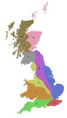
[citation needed] In England and Wales, the six single-digit numbers reflect the traditionally most important radial routes coming out of London, Starting with the A1 which heads due north, numbers were allocated sequentially in a clockwise direction, thus:[citation needed] Similarly, in Scotland, important roads radiating from Edinburgh have single-digit numbers, thus: While these routes remain the basis for the numbering of the A road network, they are no longer necessarily major roads, having been bypassed by motorways or other changes to the road network.
These roads have been numbered either outwards from or clockwise around their respective hubs, depending on their alignment.
[10] This is due to the rural nature of Devon's topology making some roads unsuitable for certain types of vehicle.
The classification is denoted by the colour of the sign border and direction arrow, and can be summarised as follows: Roads and lanes with yet lower traffic densities are designated as unclassified roads commonly using C, D and U prefixes but, while these are numbered, in general this is done for use by the local authorities who are responsible for maintaining them and the non-unique numbering is in a local series which usually does not appear on road signs;[citation needed] use of local numbers on signs in England is "not advised".