Aargau
[6] The reconstructed Old High German name of Aargau is Argowe, first unambiguously attested (in the spelling Argue) in 795.
Within the Frankish Empire (8th to 10th centuries), the area was a disputed border region between the duchies of Alamannia and Burgundy.
This division became the ill-defined (and sparsely settled) outer border of the early Holy Roman Empire at its formation in the second half of the 10th century.
When Frederick IV of Habsburg sided with Antipope John XXIII at the Council of Constance, Emperor Sigismund placed him under the Imperial ban.
The Confederation was able to quickly conquer the towns of Aarau, Lenzburg, Brugg and Zofingen along with most of the Habsburg castles.
Bern kept the southwest portion (Zofingen, Aarburg, Aarau, Lenzburg, and Brugg), northward to the confluence of the Aare and Reuss.
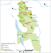
[10] Some districts, named the Freie Ämter (free bailiwicks) – Mellingen, Muri, Villmergen, and Bremgarten, with the countship of Baden – were governed as "subject lands" by all or some of the Confederates.
In 1514 Bern expanded north into the Jura and so came into possession of several strategically important mountain passes into the Austrian Fricktal.
While the Habsburgs were driven out, many of their minor nobles were allowed to keep their lands and offices, though over time they lost power to the Bernese government.
The bailiwick administration was based on a very small staff of officials, mostly made up of Bernese citizens, but with a few locals.
At the beginning of the 16th century a number of anabaptists migrated into the upper Wynen and Rueder valleys from Zürich.
The final boundary was set in 1425 by an arbitration tribunal and Lucerne had to give the three Ämter to be collectively ruled.
After the defeat of Zürich in the second Battle of Kappel in 1531, the victorious five Catholic cantons marched their troops into the Freie Ämter and reconverted them to Catholicism.
The victory gave Zürich the opportunity to force the Catholic cantons out of the government in the county of Baden and the adjacent area of the Freie Ämter.
The Freie Ämter were then divided in two by a line drawn from the gallows in Fahrwangen to the Oberlunkhofen church steeple.
All these overlapping jurisdictions caused numerous conflicts, but gradually the Confederation was able to acquire these rights in the county.
Together with the courts, the three administrative centers had considerable local autonomy, but were ruled by a governor who was appointed by the Acht Orte every two years.
The governors were appointed from both Catholic and Protestant cantons and since they changed every two years, neither faith gained a majority in the county.
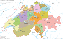
[15] After the French invasion, on 19 March 1798, the governments of Zürich and Bern agreed to the creation of the short lived canton of Baden in the Helvetic Republic.
After World War II, this formerly agrarian region saw striking growth and became the district with the largest and densest population in the canton (110,000 in 1990, 715 persons per km2).
Aborted plans to merge the two halves came in 1801 and 1802, and they were eventually united under the name Aargau,[5][16] which was then admitted as a full member of the reconstituted Confederation following the Act of Mediation.
While the rural upper class pressed incessantly for the expulsion the Jews, the financial interests of the authorities prevented it.
They were still restricted to Endingen and Lengnau until 7 May 1846, when their right to move and reside freely within the canton of Aargau was granted.
The time of 1860 saw the canton government voting to grant suffrage in all local rights and to give their communities autonomy.
As the island was repeatedly flooded and devastated, in 1750 the Surbtal Jews asked the Tagsatzung to establish the Endingen cemetery in the vicinity of their communities.
The surface of the country is diversified with undulating tracts and well-wooded hills, alternating with fertile valleys watered mainly by the Aare and its tributaries.
[5] The historical population is given in the following chart:[26][27][28] In the 2011 federal election, the most popular party was the SVP which received 34.7% of the vote.
The number of jobs in the primary sector was 7,167, of which 6,731 were in agriculture, 418 were in forestry or lumber production and 18 were in fishing or fisheries.
[7] The canton is also industrially developed, particularly in the fields of electrical engineering, precision instruments, iron, steel, cement and textiles.
[33] Tourism is significant, particularly for the hot springs at Baden and Schinznach-Bad, the ancient castles, the landscape, and the many old museums in the canton.