Aberdeen Harbour
The port was first established in 1136 and has been continually redeveloped over the centuries to provide a base for significant fishing and ship building industries.
This £420million extension added 1.5km of deep water berthage to support cruise ships, cargo vessels and the Offshore wind sector.
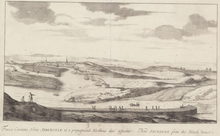
At that time the river entered the area from the south west on a northerly course before turning eastwards towards the sea, featuring a series of channels and islets (known locally as 'inches').
It is thought that these channels, sandbanks and islets changed position over time, as maps dating from 1661 and 1773 show noticeably different arrangements.
Coastal currents and northerly winds would often allow a sandbank to form at the mouth of the river, leaving a water depth of only a few feet.
[2] The first known improvements to address these issues are recorded in a charter dating from 1281, which indicates that a bulwark ran southwards from the bottom of Shiprow.
[4] During 1595 King James VI issued a charter to raise funding for improvements, with considerable work thereafter being undertaken, including repair of the bulwark, pier, shore and harbour.
It was formed from a drystone construction with timber stakes and positioned so that it would deflect the current of the river northwards, washing away the sandbank.
[6] The layout of the modern harbour, as it largely remains today, can be traced back to around 1770, when planning for extensive development begun.
Civil engineer John Smeaton oversaw the construction of a breakwater (which became known as the North Pier) between 1775 and 1781 at Sandness (now known as Footdee or locally as Fittie).
This included work to extend the North Pier to 610 metres (670 yd; 2,000 ft) to a point which terminated amongst rocks which had resulted in at least five shipwrecks.
Improvements also involved the construction of a wet dock and spillway, and the diversion of the River Dee, all overseen by resident harbour engineer John Gibb.
[2] The work resulted in the demolition of much of Old Torry on the south side of the river, the separate burgh being incorporated into the City of Aberdeen during 1891.
The fleet also comprised around thirty larger great-line boats, which would typically be at sea for up to 28 days and fished in deeper waters, predominately for halibut.
[32] The Victoria Dock was redeveloped and the tide locks at Waterloo Quay were removed in 1975, resulting in the whole harbour again becoming tidal, with dredging occurring as necessary to maintain the required depths.
[42] The Walter Hood & Co. shipyard opened in 1839 and was located adjacent to Pocra jetty, east of the Hall Russell yard.
In 1861, the yard became John Duthie, Sons & Co. and throughout the 1860s continued to produce vessels constructed from timber, despite competitors developing use of composite designs and iron.
[44] John Lewis & Sons was established in 1907, initially producing and repairing marine engines at Maitlands Quay area in Torry.
Post-war, Hall Russell constructed trawlers and cargo ships, including the freighter Thameshaven in 1971, which was Aberdeen's largest ever vessel with a deadweight of 10,500 tonnes.
[48] The site was redeveloped to create the Telford Dock, which provided five new deep-water berths, a jetty, two transit sheds and 26,000sqm of heavy-duty paved open storage.
It was designed by SMC Parr Architects and is reminiscent of a traditional lighthouse, utilising precast concrete with white aggregate as well as faceted curtain wall glazing.
Its prominent location at the mouth of the River Dee allows Vessel Traffic Services (VTS) staff to have an overview of the various docks and harbour entrance.
[77] The River Dee, including the stretch within the harbour boundaries, is designated as a Special Area of Conservation under the European Union's Habitats Directive (92/43/EEC), because of its populations of freshwater pearl mussel, Atlantic salmon and otter.
[80] The Roundhouse's role was replaced by the Marine Operations Centre in 2006, with the harbour board retaining ownership of the building and leasing it out as office space.
It is described by Historic Environment Scotland as a rare survivor of its type, notable for its unusual octagonal form and relatively early construction date.
[80] Scarty's Monument is a brick obelisk located at Pocra Quay, named after a harbour pilot who kept watch during poor weather from the North Pier in the mid 19th century.
[82] 6 Regent Road (also known as United House) located between the Victoria and Albert Docks, is an example of a late 19th century warehouse associated with the harbour.
The two polished grey granite ashlar buildings are described by Historic Environment Scotland as being of some quality with fine Classical architectural detailing and cast-iron rainwater goods.
It is also noted that functional buildings of this type with such attention to detail are rare and that they contribute significantly to the built environment of the harbour.
[84] Located at Pocra Quay adjacent to the Roundhouse, the Abercrombie Jetty (also known as the 'Catch Pier') was constructed in 1789 as part of wider harbour improvements.