Acadia National Park
Woven into this landscape is a historic carriage road system financed by John D. Rockefeller Jr.[4] In total, it encompasses 49,075 acres (19,860 ha; 76.680 sq mi; 198.60 km2) as of 2017[update].
Recreational activities from spring through autumn include car and bus touring along the Park Loop Road; hiking, bicycling, and horseback riding on carriage roads (motor vehicles are prohibited); fishing; rock climbing; kayaking and canoeing on lakes and ponds; swimming at Sand Beach and Echo Lake; sea kayaking and guided boat tours on the ocean; and various ranger-led programs.
[22] The etymology of the park's name begins with the Mi'kmaq term akadie ("piece of land") which was rendered as l'Acadie by French explorers, and translated into English as Acadia.
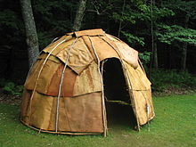
[22] In the early 17th century, Asticou was the chieftain of the greater Mount Desert Island area, one district of an intertribal confederacy known as Mawooshen led by the grandchief Bashaba.
By the early 1620s, warfare and introduced diseases, including smallpox, cholera and influenza, had decimated the tribes from Mount Desert Island southward to Cape Cod, leaving about 10 percent of the original population.
Some Wabanakis live on Mount Desert Island, while others visit for board meetings at the Abbe Museum, to advise on and perform in exhibitions, for craft demonstrations, and to gather sweetgrass and sell handmade baskets at the annual festival.
[25] While he was sailing down the coast on 5 September 1604,[27] Champlain wrote: That same day we also passed near an island about four or five leagues [12–15 mi; 19–24 km] in length, off which we were almost lost on a little rock, level with the surface of the water, which made a hole in our pinnace close to the keel.
Mount Desert Island, being remote from the cities of the east, became a summer retreat for families such as the Rockefellers, Morgans, Fords, Vanderbilts, Carnegies, and Astors.
For more than forty years, the wealthy dominated summer activity on Mount Desert Island, but the Great Depression and World War II brought an end to the extravagance.
[4] We have entered on an important work; we have succeeded until the Nation itself has taken cognizance of it and joined with us for its advancement...No one who had not made the study of it which I have can realize how various and truly wonderful the opportunities are which the creation of this Park now opens, alike in wild life ways and splendid scenery.
[10] He sponsored the landscape architect Beatrix Farrand, whose family owned a summer home in Bar Harbor named Reef Point Estate, to design the planting plans for the carriage roads (c.
[39] The network originally encompassed about 57 miles (92 km)[9] of crushed stone carriage roads with 17 stone-faced, steel-reinforced concrete bridges (16 financed by Rockefeller), and two gate lodges—one at Jordan Pond and the other near Northeast Harbor.
The fire burned until November 14, and was fought by the Coast Guard, Army Air Corps, Navy, local residents, and National Park Service employees from around the country.
The Cadillac Mountain Intrusive Complex is part of the Coastal Maine Magmatic Province, consisting of over a hundred mafic and felsic plutons associated with the Acadian Orogeny.
[53] More than 500 Mya, layers of mud, sand and volcanic ash were buried beneath the ocean where high pressure, heat and tectonic activity created a metamorphic rock formation called the Ellsworth Schist.
The collision buried the schist along with accumulations of sand and silt, creating the Bar Harbor Formation which consists of brown and gray sandstone and siltstone layers.
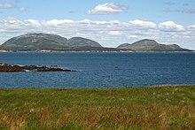
The mountain range was heavily eroded by the glacier which rounded off mountaintops, carved saddles, deepened valleys, and created the fjard known as Somes Sound, nearly dividing the current island in half.
[21] Evidence of the last glacial period, the Wisconsin glaciation from about 75,000 to 11,000 years ago, is visible as long scratches, or striations, and crescent-shaped gouges created by material carried along at the base of the ice.
[54] The coastal areas of Maine sank slightly under the extreme weight of the ice sheets, allowing seawater to cover lowlands thus forming the present-day islands.
Coastal areas directly facing the wind-driven waves of the Atlantic Ocean are solely composed of large boulders as all other material has been washed out to sea.
Sheltered coves, such as at Sand Beach, contain fine-grained particles that are primarily the remains of shells and other hard parts of marine life, including mussels and sea urchins.
Saturated soils, thawing, and heavy precipitation lead to rockfalls every spring along Mount Desert Island's loop road, as well as slumping along coastal bluffs.
[55] Mass wasting (slope movement) of marine clay, deposited when the sea level was much higher, occurs along Hunters Brook on Mount Desert Island.
Invertebrate fossils include foraminifera (protists that form test shells), sponge spicules, bryozoans, bivalves, gastropods, Spirorbis, beetles, ants, barnacles, decapod crustaceans (crabs, shrimp, lobsters, etc.
Pools of calm water form among the rocks around low tides, inhabited by starfish, dog whelks, blue mussels, sea cucumbers, and rockweed.
[56] Flora common to both deciduous and coniferous woodlands include lowbush blueberry, Canadian bunchberry, hobblebush, bluebead lily, Canada mayflower, wild sarsaparilla, shadbush, starflower, rosy twisted stalk, wintergreen, and white pine trees.
[4] Other coniferous forest plants include dewdrop, mountain holly, pinesap, one-flowered pyrola, shinleaf, trailing arbutus, northern woodsorrel, and drooping woodreed.
[63] Many marine species may be observed in the surrounding waters, including seals and whales, from a sea kayak or other personal watercraft, or on ranger-narrated boat cruises.
[69][70] Motor vehicle touring along the 27-mile (43 km) Park Loop Road begins on April 15, if weather permits, and ends on December 1, unless significant snowfall closes it sooner.
[96] The Acadia Youth Conservation Corps was established by FOA and endowed by an anonymous donor in 1999 to employ 16 high school students in maintenance of trails and carriage roads in the summer months.
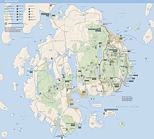
(click map to enlarge)