Aerial photograph interpretation (geology)
[1] It allows geologists to analyze the distinguishing geological features and structures, plant cover, past history of the site, soil properties, and topography of the study area.
[1] It is also commonly used in other industries such as forest management, environmental science, disciplines of engineering, and investigating aviation accidents.
[1][3][4] Aerial photograph interpretation is also useful to assess the risk of landslides and other dangers in the natural environment in the geotechnical industry.
[5] As proper interpretation of aerial photos can reveal historical changes of the topography and the details of previous landslides, it can be help determine whether an area is stable or not.
[5] Aerial photographs play an important role in assessing the risk of different natural hazards, particularly landslides.
[1] The majority of naturally occurring landslides happen in isolated locations, posing a threat to ongoing development.
Aerial photographs are helpful for geologists to observe large-scale geological structures without spending large amounts of time in fields.
This helps detect dangers from the falling of these large rock pieces, especially when conducting new projects close to the hillsides.
From the vertical view of the aerial photograph, the positions and relative dimensions of the boulders can be determined and measured easily.
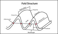
[1] Aerial photographs can be used to help study, recognize, and classify landforms, which refers to the topographical characteristics created by the environmental systems.
[1] Differences in terrain surface elevation, river flow, colors of the aerial photographs, spatial distribution of tones, and the occurrence of plant covers are considered during landform studies.
and river courses[5] Regolith mapping helps distinguish different kinds of superficial deposits which refer to loosely arranged aggregates of weathered materials on the land surface.
Valley colluvium refers to the loose, unconsolidated sediments that have been settled inside the water courses and are driven by river mechanisms.
[1] Debris fan colluvium refers to the aggregates of gravity-driven and fluvial deposits located near the hillslope's base or the eroded catchment area.
[1] For example, agricultural terraces, which refers to the level land surfaces divided by short back slopes and concrete barriers, is one of the disrupted landscapes.

![Sketch diagram showing the aerial photograph of Pat Heung in 1989 in Hong Kong. It shows how the yellow current landslides were identified within the red study area on the slopes of the natural terrain using interpretation techniques. A total of seven current landslides were identified. The numbers and years of occurrence are marked with the respective current landslides.[1] (not in scale)](http://upload.wikimedia.org/wikipedia/commons/thumb/0/07/Landslides_from_hk.png/220px-Landslides_from_hk.png)