Airspace
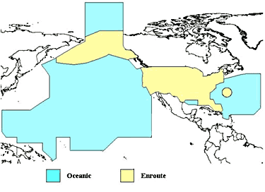
[3] Airspace not within any country's territorial limit is considered international, analogous to the "high seas" in maritime law.
Such airspace in respect of which a country is responsible under the International Civil Aviation Organization (ICAO) for operational control is called a Flight Information Region (FIR).
[4] For instance, the United States provides air traffic control services over a large part of the Pacific Ocean, even though the airspace is international.
[7] The Fédération Aéronautique Internationale has established the Kármán line—at an altitude of 100 km (62 mi)—as the boundary between the Earth's atmosphere and outer space.
[8] However, descending Space Shuttles flew closer than 80 km (50 mi) over other nations, such as Canada, without requesting permission first.
[6] Nonetheless, both the Kármán line and the U.S. definition are merely working benchmarks, without any real legal authority over matters of national sovereignty.
However, this only applied in times of peace and if it was to the advantage of the states, there was no clear demarcation of the airspace question until the 1950s when the Kármán line was defined.
[citation needed] The boundary between public airspace and private air rights is defined by national or local law.
In the United States, the 1946 Supreme Court decision United States v. Causby overturned the common law doctrine that private property rights extend indefinitely upwards, instead ruling that they end 300 feet above the highest terrain (including buildings), the lower limit of the "public highway" defined by Congress in the Air Commerce Act of 1926.
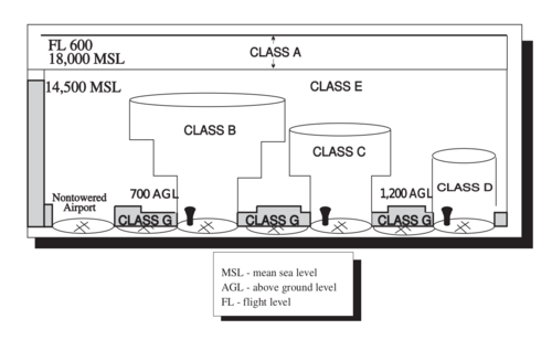
[14] Class C airspace is generally airspace from the surface to 4,000 feet above the airport elevation (charted in MSL) surrounding those airports that have an operational control tower, are serviced by a radar approach control, and have a certain number of IFR operations or passenger enplanements.
Prohibited areas in the United States are published in the Federal Register and are depicted on aeronautical charts.
Examples of prohibited areas include Camp David and the National Mall in Washington, D.C., where the White House and the Congressional buildings are located.
Restricted areas denote the existence of unusual, often invisible, hazards to aircraft (e.g., artillery firing, aerial gunnery, or guided missiles).
[14] ATC facilities apply the following procedures when aircraft are operating on an IFR clearance (including those cleared by ATC to maintain VFR on top) via a route which lies within joint-use restricted airspace: Restricted areas are charted with an "R" followed by a number (e.g., R-4401) and are depicted on the en route chart appropriate for use at the altitude or FL being flown.
A warning area is airspace of defined dimensions, extending from 12 NM outward from the coast of the United States, containing activity that may be hazardous to nonparticipating aircraft.
[15] MOAs consist of airspace with defined vertical and lateral limits established for the purpose of separating certain military training activities from IFR traffic.
[Figure 14-5] However, the MOA is also further defined on the back of the sectional charts with times of operation, altitudes affected, and the controlling agency.
[14] It includes: A service provided by facilities, which are located on the landing airport, have a discrete ground-to-air communication frequency or the tower frequency when the tower is closed, automated weather reporting with voice broadcasting, and a continuous ASOS/AWOS data display, other continuous direct reading instruments, or manual observations available to the specialist.
[14] A flight data center (FDC) Notice to Airmen (NOTAM) is issued to designate a TFR.
The NOTAM also contains the FAA coordination facility and telephone number, the reason for the restriction, and any other information deemed appropriate.
There have been a number of incidents of aircraft incursions into TFRs, which have resulted in pilots undergoing security investigations and certificate suspensions.
[14] NSAs consist of airspace of defined vertical and lateral dimensions established at locations where there is a requirement for increased security and safety of ground facilities.