Airspace class (United States)
The United States airspace system's classification scheme is intended to maximize pilot flexibility within acceptable levels of risk appropriate to the type of operation and traffic density within that class of airspace – in particular to provide separation and active control in areas of dense or high-speed flight operations.
These specific airspace blocks may be opened by ATC to allow sailplanes to fly in the lee waves of mountains.
[3] Since class A airspace is normally restricted to instrument flight only, there are no minimum visibility requirements.
Many class B airspaces diverge from this model to accommodate traffic patterns or local topological or other features.
[6] Furthermore, aircraft overflying the upper limit of any class B airspace must have an operating Mode C transponder.
[5] VFR flights operating in class B airspace must have three miles (5 km) of visibility and must remain clear of clouds (no minimum distance).
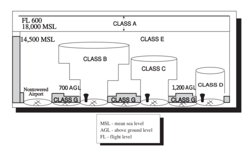
The upper "shelf" area has a radius of ten nautical miles, and extends from as low as 1,200 feet (370 m) up to the ceiling of the airspace.
[8] All aircraft entering class C airspace must establish two-way radio communication with ATC prior to entry; explicit clearance to enter is not required; however, the controller of Class C space may instruct aircraft initiating communication to "remain outside" the airspace.
The aircraft must be equipped with a two-way radio and an operating Mode C (altitude reporting) radar transponder, furthermore aircraft overflying above the upper limit of class C airspace upward to 10,000 feet MSL must have an operating Mode C transponder.
Aircraft speeds must be below 200 knots (230 mph) at or below 2,500 feet (760 m) above the ground, and within 4 nautical miles (7 km) of the class C airport.
Class D airspace is generally cylindrical in form and normally extends from the surface to 2,500 feet (760 m) above the ground.
[9] Two-way communication with ATC must be established before entering class D airspace, but no transponder is required.
VFR visibility and cloud clearance requirements are the same as for class C and D airspaces when below 10,000 feet (3,000 m) MSL.
By day at 1,200 feet (370 m) AGL and below, aircraft must remain clear of clouds, and there is no minimum lateral distance.
A warning area is airspace of defined dimensions, extending from three nautical miles outward from the coast of the U.S., that contains activity that may be hazardous to non-participating aircraft.
[15] Entry into prohibited areas is forbidden under all circumstances, except for an emergency, and the only aircraft that can access such specific areas are military aircraft with extremely special clearance, such as Marine One landing on the White House's South Lawn.
MOAs serve as a warning, since military aircraft often fly at high speeds and are intentionally difficult to see.
When it is necessary to provide a greater level of security and safety, flight in NSAs may be temporarily prohibited by regulation under the provisions of 14 CFR Section 99.7.
At these airports Flight Service also serves the function of relaying ATC clearances to IFR aircraft.
They are designated in high volume traffic areas where radar services are available, but not otherwise designated as class B or C airspace, such as in the Palm Springs area in Southern California where high mountainous terrain channels air traffic into the same busy space.
Temporary flight restrictions are designated by NOTAM and are used to clear the airspace in special circumstances that could be hazardous to aircraft not participating in the event for which the TFR was issued.
[22] Situations in which TFRs are typically used include forest fires and other natural disasters, air shows, some instances of criminal activity, extensions of restricted airspace to allow expansion of military training operations, and during movement of the President and certain other high-level government officials.
[23] While the altitude limits of each route are not depicted on ordinary charts, the numbering system partially reveals this information.
Specific conventions are used to indicate airspace boundaries on VFR sectional and terminal area charts (TACs) for the United States.
In other cases, the boundaries may follow natural topological features or may be defined in other ways, which may or may not be explicitly indicated on the chart.
In other cases, the boundaries may follow natural topological features or may be defined in other ways, which may or may not be explicitly indicated on the chart.
Class D airspace is delimited by a thin, dashed blue line, generally in the form of a circle centered on an airport.
Class E airspace is denoted in different ways depending on its lower altitude limit.
Class E airspace that begins at 700 feet (210 m) AGL is delimited by a broad, shaded magenta border.
In many cases, the expanse of airspace that is class E beginning at 1,200 feet (370 m) AGL is so large that only the areas that differ are marked on the chart.