Boundary Waters Canoe Area Wilderness
Efforts to preserve the primitive landscape began in the 1900s and culminated in the Boundary Waters Canoe Area Wilderness Act of 1978.
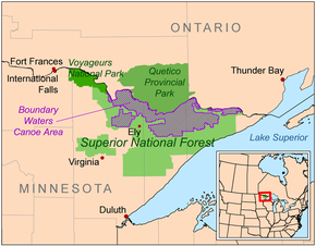
The combined region of the BWCAW, Superior National Forest, Voyageurs National Park, and Ontario's Quetico and La Verendrye provincial parks make up a large area of contiguous wilderness lakes and forests called the "Quetico-Superior country", or simply the Boundary Waters.
[2] The Laurentian Divide between the watersheds of the Great Lakes and Hudson Bay runs northeast–southwest through the east side of the BWCAW, following the crest of the Superior Upland and Gunflint Range.
[4]: 9 The crossing of the divide at Height of Land Portage was an occasion for ceremony and initiation rites for the fur-trading Voyageurs of the 18th and early 19th centuries.
[2] Located around the perimeter of the BWCAW are six ranger stations: in Cook, Aurora, Ely, Isabella, Tofte and Grand Marais.
The last glacial period ended with the retreat of the Laurentide Ice Sheet from the Boundary Waters about 17,000 years ago.
Winds as high as 100 miles per hour (160 km/h) knocked down millions of trees, affecting about 370,000 acres (150,000 ha) within the BWCAW and injuring 60 people.
Although campsites and portages were quickly cleared after the storm, an increased risk of wildfire due to the large number of downed trees became a concern.
[18] In 2011, the Pagami Creek Fire grew to over 92,000 acres (37,000 ha), spreading beyond the wilderness boundary to threaten homes and businesses.
[19] Smoke from the Pagami Creek Fire drifted east and south as far as the Upper Peninsula of Michigan, Ontario, Chicago, Poland, Ukraine, and Russia.
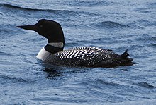
[23][24] Animals found in the BWCAW include deer, moose, beaver, timber wolves, black bears, bobcats, bald eagles, peregrine falcons, and loons.
The area then became a part of the homeland of the Ojibwe people, who traveled the waterways in canoes made of birch bark.
The Treaty of Paris, which ended the American Revolutionary War in 1783, had defined the northern border between the United States and Canada based on the inaccurate Mitchell Map.
Logging in the area began around the same time to supply lumber to support the mining industries, with production peaking in the late 1910s and gradually trailing off during the 1920s and 1930s.
[3]: 9–12 In 1902, Minnesota's Forest Commissioner Christopher C. Andrews persuaded the state to reserve 500,000 acres (200,000 ha) of land near the BWCAW from being sold to loggers.
By the early 1920s, roads had begun to be built through the Superior National Forest to promote public access to the area for recreation.
In 1926 a section of 640,000 acres (260,000 ha) within the Superior National Forest was set aside as a roadless wilderness area by Secretary of Agriculture William Marion Jardine.
In 1930, Congress passed the Shipstead-Newton-Nolan Act, which prohibited logging and dams within the area to preserve its natural water levels.
In 1948, the Thye-Blatnik Bill authorized the government to purchase the few remaining privately owned homes and resorts within the area.
In 1949, President Harry Truman signed Executive Order 10092 which prohibited aircraft from flying over the area below 4,000 feet.
[citation needed] October 1975, Eighth District Representative James Oberstar (D-MN) introduced a bill that if passed would have established a Boundary Waters Wilderness Area of 625,000 acres (253,000 ha) and a Boundary Waters National Recreation Area (NRA) of 527,000 acres (213,000 ha), permitting logging and mechanized travel in the latter area and removing from wilderness designation a number of large scenic lakes such as La Croix, Basswood, Saganaga, and Seagull.
October 21, 1978, Boundary Waters Canoe Area Wilderness Act, U.S. Public Law 95-495, was signed by President Jimmy Carter.
1990 – Friends of the Boundary Waters, Sierra Club and six other environmental groups sue to have trucks removed; CWCS joins the U S Forest Service as intervenors.
[34][35] It has been known for decades that there are about four billion tons of copper and nickel ore, "one of the world's largest undeveloped mineral deposits", in the Duluth Complex, which underlies part of northeastern Minnesota.
[38] In October 2021, the Biden administration filed an application for a "mineral withdrawal" that will put a hold on the development of the mine proposal while the environmental impacts are studied.
Day use paddle and hiking permits do not require advance reservation and can be filled out at BWCAW entry points.
The permits are for an indefinite length, although visitors are only allowed one entry into the wilderness and cannot stay in one campsite for more than 14 nights.
[46] The BWCAW's size and abundance of campsites, lakes, rivers and portage trails allow for almost countless options for different routes.
[50] "It differs from other Dark Sky designations in that sanctuaries are the most remote and often darkest places in the world whose conservation state is 'most fragile'.
Dark skies, starry nights, and astonishing northern lights displays have been part of the experience long before the area was designated wilderness..."[51]