Aksai Chin
Aksai Chin is a region administered by China partly in Hotan County, Hotan Prefecture, Xinjiang[2] and partly in Rutog County, Ngari Prefecture, Tibet and constituting the easternmost portion of the larger Kashmir region that has been the subject of a dispute between India and China since 1959.
Aksai Chin was first mentioned by Muhammad Amin, the Yarkandi guide of the Schlagintweit brothers, who were contracted in 1854 by the British East India Company to explore Central Asia.
[3] Amin's Aksai Chin was not a defined region, stretching indefinitely east into Tibet south of the Kunlun Mountains.
[19] The current meaning of the term is the area under dispute between India and China, having evolved in repeated usage since Indian independence in 1947.
[20] For military campaigns, the region held great importance, as it was on the only route from the Tarim Basin to Tibet that was passable all year round.
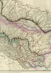
Johnson presented this line to the Maharaja of Kashmir, who then claimed the 18,000 square kilometres contained within,[26][unreliable source?]
The Maharajah of Kashmir constructed a fort at Shahidulla (modern-day Xaidulla), and had troops stationed there for some years to protect caravans.
[30] In 1897, a British military officer, Sir John Ardagh, proposed a boundary line along the crest of the Kun Lun Mountains north of the Yarkand River.
[27] At that time, Britain was concerned about the danger of Russian expansion as China weakened, and Ardagh argued that his line was more defensible.
In 1893, Hung Ta-chen, a senior Chinese official at St. Petersburg, gave maps of the region to George Macartney, the British consul general at Kashgar, which coincided in broad details.
[31] In 1899, Britain proposed a revised boundary, initially suggested by Macartney and developed by the Governor General of India Lord Elgin.
The Karakoram Mountains formed a natural boundary, which would set the British borders up to the Indus River watershed while leaving the Tarim River watershed in Chinese control, and Chinese control of this tract would present a further obstacle to Russian advance in Central Asia.
At this point the British had still made no attempts to establish outposts or control over the Aksai Chin, nor was the issue ever discussed with the governments of China or Tibet, and the boundary remained undemarcated at India's independence.
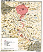
[20] On 1 July 1954, Prime Minister Jawaharlal Nehru wrote a memo directing that the maps of India be revised to show definite boundaries on all frontiers.
[40] The Indian position, as stated by Prime Minister Nehru, was that the Aksai Chin was "part of the Ladakh region of India for centuries" and that this northern border was a "firm and definite one which was not open to discussion with anybody".
[20] In June 2006, satellite imagery on the Google Earth service revealed a 1:500[41] scale terrain model of eastern Aksai Chin and adjacent Tibet, built near the town of Huangyangtan, about 35 kilometres (22 mi) southwest of Yinchuan, the capital of the autonomous region of Ningxia in China.
Local authorities in Ningxia claim that their model of Aksai Chin is part of a tank training ground, built in 1998 or 1999.
[55] The area is largely a vast high-altitude desert with a low point (on the Karakash River) at about 4,300 m (14,100 ft) above sea level.
In the southwest, mountains up to 7,000 m (23,000 ft) extending southeast from the Depsang Plains form the de facto border (Line of Actual Control) between Aksai Chin and Indian-controlled Kashmir.
In the north, the Kunlun Range separates Aksai Chin from the Tarim Basin, where the rest of Hotan County is situated.
According to a recent detailed Chinese map, no roads cross the Kunlun Range within Hotan Prefecture, and only one track does so, over the Hindutash Pass.
Much of the northern part of Aksai Chin is referred to as the Soda Plains, located near Aksai Chin's largest river, the Karakash, which receives meltwater from a number of glaciers, crosses the Kunlun farther northwest, in Pishan County and enters the Tarim Basin, where it serves as one of the main sources of water for Karakax and Hotan Counties.
[62] In the 1860s to 1870s, in order to facilitate trade between the Indian subcontinent and Tarim Basin, the British attempted to promote a caravan route via the western side of Aksai Chin as an alternative to the difficult and tariffed Karakoram Pass.