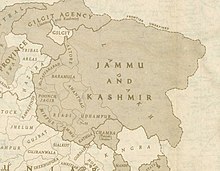
Azad Kashmir
[1] Azad Kashmir also shares borders with the Pakistani provinces of Punjab and Khyber Pakhtunkhwa to the south and west, respectively.
Azad Kashmir's economy largely depends on agriculture, services, tourism, and remittances sent by members of the British Mirpuri community.
[13] However, the following year, the party passed an "Azad Kashmir resolution" demanding that the maharaja institute a constituent assembly elected on an extended franchise.
[15] According to scholar Chitralekha Zutshi, the organisation's declared goal was to achieve responsible government under the aegis of the maharaja without association with either India or Pakistan.
[16] The following year, the party workers assembled at the house of Sardar Ibrahim on July 19, 1947, reversed the decision, demanding that the Maharaja accede to Pakistan.
[19] On October 4, an Azad Kashmir provisional government was declared in Lahore with Ghulam Nabi Gilkar as president under the assumed name "Mr. Anwar" and Sardar Ibrahim as the prime minister.
The area's population, swelled by recently demobilised soldiers following World War II, rebelled against the maharaja's forces and gained control of almost the entire district.
Following this victory, the pro-Pakistan chieftains of the western districts of Muzaffarabad, Poonch and Mirpur proclaimed a provisional Azad Jammu and Kashmir government in Rawalpindi on October 3, 1947.
[28] On October 21, several thousand Pashtun tribesmen from North-West Frontier Province poured into Jammu and Kashmir to help with the rebellion against the maharaja's rule.
Accordingly, on October 26, 1947, Maharaja Hari Singh signed an Instrument of Accession, handing over control of defence, external affairs, and communications to the Government of India in return for military aid.
[31] India later approached the United Nations, asking it to resolve the dispute, and resolutions were passed in favour of the holding of a plebiscite with regard to Kashmir's future.
[34] In 1970, Yahya Khan's military administration promulgated a 'rudimentary' constitution, 'The Azad Jammu and Kashmir Government Act, 1970' which provided AJK a presidential system, an elected legislative assembly and 'considerable' autonomy.
"[35]: 121–122 Danish Khan in The Friday Times characterizes this development as providing "an avenue for citizens to draw attention from political elites towards immediate socio-economic and developmental concerns such as access to basic infrastructure and public goods," further stating "while public sector investments in infrastructure and social sectors have shown relative improvements over the years, the overarching narrative in the political sphere, spanning across party lines, remains heavily focused on the Jammu & Kashmir conflict rather than indigenous socio-economic development.
This line has remained unchanged[39] since the 1972 Simla Agreement, which bound the two countries "to settle their differences by peaceful means through bilateral negotiations".
Some political experts claim that, in view of that pact, the only solution to the issue is mutual negotiation between the two countries without involving a third party such as the United Nation.
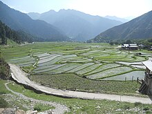
"[42] The northern part of Azad Jammu and Kashmir encompasses the lower area of the Himalayas, including Jamgarh Peak (4,734 m or 15,531 ft).
During the summer season, monsoon floods of the rivers Jhelum and Leepa are common due to extreme rains and snow melting.
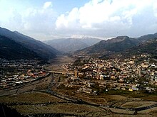
[citation needed] In the central and northern parts of the state, the weather remains moderately hot in the summer and cold and chilly in the winter.
[2][44] Azad Kashmir has its own elected president, prime minister, legislative assembly, high court (with Azam Khan as its present chief justice), and official flag.
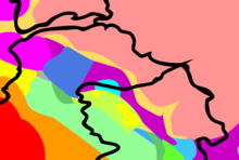
[57] Christopher Snedden writes that most of the native residents of Azad Kashmir are not of Kashmiri ethnicity; rather, they could be called "Jammuites" due to their historical and cultural links with that region, which is coterminous with neighbouring Punjab and Hazara.
There are also sizeable communities speaking Kashmiri (mostly in the north), Gujari (throughout the territory), and Dogri (in the south), as well as pockets of speakers of Kundal Shahi, Shina and Pashto.
Those are also spoken across the Line of Control in the neighbouring areas of Indian Jammu and Kashmir and are closely related both to Punjabi to the south and Hindko to the northwest.
The dialects of the central districts of Azad Kashmir are occasionally referred to in the literature as Chibhali or Punchi, but the speakers themselves usually call them Pahari, an ambiguous name that is also used for several unrelated languages of the lower Himalayas.
Today, in the Muzaffarabad District the preferred local name for the language is Hindko, although it is still apparently more closely related to the core dialects of Pahari.
[87] There is an ongoing process of gradual shift to larger local languages,[79] but at least in the Neelam Valley there still exist communities for whom Kashmiri is the sole mother tongue.
Pashto, of the Iranian subgroup and the majority language in the neighbouring province of Khyber Pakhtunkhwa, is spoken in two villages, both situated on the Line of Control.
Low-lying areas that have high populations grow crops like barley, mangoes, millet, corn (maize), and wheat, and also raise cattle.
Agricultural goods produced in the region include mushrooms, honey, walnuts, apples, cherries, medicinal herbs and plants, resin, deodar, kail, chir, fir, maple, and ash timber.
[93] In addition to agriculture, textiles, and arts and crafts, remittances have played a major role in the economy of Azad Kashmir.
[94] In the latter part of 2006, billions of dollars for development were mooted by international aid agencies for the reconstruction and rehabilitation of earthquake-hit zones in Azad Kashmir, though much of that amount was subsequently lost in bureaucratic channels, leading to considerable delays in help getting to the neediest.