Alarmstange
In 1853, a post was erected that acted as a trigonometric point for the surveying of the Rhineland which was begun by Jean-Joseph Tranchot and continued by Friedrich Carl Ferdinand von Müffling.
On the summit region and southern flank of the Alarmstange are parts of a Special Area of Conservation, the Montabauer Heights (Montabaurer Höhe, FFH no.
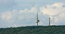
[5] The Alarmstange is 545.2 m.[1] Roughly 150 metres southwest of the summit on topographical maps is a spot height of 542.5 m.[1] Atlases and larger maps give its height as 545 m[6] or 546 m.[2] About 130 metres southwest of the summit of the Alarmstange stands the99-metre-high Hillscheid-Alarmstange Tower built in 1971 (50°25′27.8″N 7°43′55.5″E / 50.424389°N 7.732083°E / 50.424389; 7.732083 (Fernmeldeturm Hillscheid-Alarmstange)) belonging to Deutsche Funkturm with its amateur radio relay repeater.
150 metres west of this tower is the air quality survey station of Neuhäusel, which is part of the ZIMEN network of the State Office for the Environment, Water and Trade.
The Landesstraße 309 and German Limes Road run over the southern slopes of the Montabaur Heights and the Alarmstange between Hillscheid and the Bundesstraße 49, roughly from west to east.