Geographic coordinate system
[2] A full GCS specification, such as those listed in the EPSG and ISO 19111 standards, also includes a choice of geodetic datum (including an Earth ellipsoid), as different datums will yield different latitude and longitude values for the same location.
[3] The invention of a geographic coordinate system is generally credited to Eratosthenes of Cyrene, who composed his now-lost Geography at the Library of Alexandria in the 3rd century BC.
In the 1st or 2nd century, Marinus of Tyre compiled an extensive gazetteer and mathematically plotted world map using coordinates measured east from a prime meridian at the westernmost known land, designated the Fortunate Isles, off the coast of western Africa around the Canary or Cape Verde Islands, and measured north or south of the island of Rhodes off Asia Minor.
After their work was translated into Arabic in the 9th century, Al-Khwārizmī's Book of the Description of the Earth corrected Marinus' and Ptolemy's errors regarding the length of the Mediterranean Sea,[note 1] causing medieval Arabic cartography to use a prime meridian around 10° east of Ptolemy's line.
In 1884, the United States hosted the International Meridian Conference, attended by representatives from twenty-five nations.
Twenty-two of them agreed to adopt the longitude of the Royal Observatory in Greenwich, England as the zero-reference line.
[6] France adopted Greenwich Mean Time in place of local determinations by the Paris Observatory in 1911.
This is not to be conflated with the International Date Line, which diverges from it in several places for political and convenience reasons, including between far eastern Russia and the far western Aleutian Islands.
The combination of these two components specifies the position of any location on the surface of Earth, without consideration of altitude or depth.
In order to use the theoretical definitions of latitude, longitude, and height to precisely measure actual locations on the physical earth, a geodetic datum must be used.
Traditionally, this binding was created by a network of control points, surveyed locations at which monuments are installed, and were only accurate for a region of the surface of the Earth.
Newer datums are based on a global network for satellite measurements (GNSS, VLBI, SLR and DORIS).
Because any spatial reference system or map projection is ultimately calculated from latitude and longitude, it is crucial that they clearly state the datum on which they are based.
Examples of global datums include the several realizations of WGS 84 (with the 2D datum ensemble EPSG:4326 with 2 meter accuracy as identifier)[10][11] used for the Global Positioning System,[note 3] and the several realizations of the International Terrestrial Reference System and Frame (such as ITRF2020 with subcentimeter accuracy), which takes into account continental drift and crustal deformation.
WGS 84 differs at Greenwich from the one used on published maps OSGB36 by approximately 112 m. ED50 differs from about 120 m to 180 m.[13] Points on the Earth's surface move relative to each other due to continental plate motion, subsidence, and diurnal Earth tidal movement caused by the Moon and the Sun.
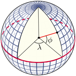
The circles of longitude, meridians, meet at the geographical poles, with the west–east width of a second naturally decreasing as latitude increases.
Similarly, the length in meters of a degree of longitude can be calculated as (Those coefficients can be improved, but as they stand the distance they give is correct within a centimeter.)
is 6,367,449 m. Since the Earth is an oblate spheroid, not spherical, that result can be off by several tenths of a percent; a better approximation of a longitudinal degree at latitude