Alauna, France
In the Middle Ages, when urbanization resumed in Valognes especially near the Merderet, Alauna became the land for agricultural activities, primarily for livestock farming, a vocation that continues into the 21st century in a Norman bocage [fr] landscape.
Alauna is situated 1.6 km southeast of Alleaume [fr] on the northwest edge of a plateau between two parallel thalwegs oriented northwest-southeast, which limit it to the east and west.
[7] The Peutinger Table indicates that the ancient station of Alauna, which is not represented by a vignette like important towns, was situated on the Roman road connecting it to Coriallo (Cherbourg).
[12] In addition to the main routes that have been confirmed by archaeological evidence, Alauna was also situated at the heart of a network of ancient roads and paths that irrigated the peninsula up to the Cap de la Hague.
[14] The southern decumanus identified in the ancient city appears to have played a significant role in facilitating long-distance connections, with its extensions seemingly oriented towards Portbail to the west and the Baie des Veys [fr] to the east.
While some historians and archaeologists proposed that Alauna could be the chief town of the Unelli civitas since the 17th century, others have suggested that this role may belong to Crociatonum (Saint-Côme-du-Mont or Carentan) or Cosedia/Constancia (Coutances).
A large enclosure, open to the east by a monumental porch, is linked to an agricultural operation with a metallurgy workshop, located immediately west of the perimeter of the ancient city.
[32] This was followed by a phase of territorial expansion and monumentalization in the second half of the 1st or early 2nd century, with the construction of large complexes such as baths, an entertainment building, and likely a new forum and remodeled sanctuary.
It is likely that the road network was initially sketched out from Alauna's foundation, but was subsequently completed and adjusted according to the needs of the expansion phase, which involved the reclamation of the space that had been occupied during the Iron Age.
While the underlying causes remain uncertain and may vary from one site to another,[35] the main monuments of the city were progressively abandoned, and the artifacts found (ceramics, coins) became increasingly scarce.
[47] In 1765, Anne Claude de Caylus published drawings and a partial plan of this establishment by engineer René Cevet in the seventh volume of his Recueil d'antiquités égyptiennes, étrusques, grecques, romaines et gauloises.
[50] In the 19th century, while the ruins of the baths were rarely recognized as such and the existence of the theater had largely disappeared from the memory of the inhabitants,[51] Charles de Gerville resumed research at Alauna.
[66] It serves as a starting point for tours that are organised by the AAA [fr] association in partnership with the Clos du Cotentin art and history country, notably during the European Heritage Days.
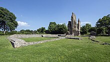
[69] The oldest and, in the early 21st century, the only remains whose function is truly attested, either because they are still partially in elevation or have been excavated, are those of probably public baths and an spectacle building [fr].
Topographical constraints and the desire to interconnect this urban network with the main roads linking neighboring towns undoubtedly play a significant role in this observation.
[83] Additionally, a limestone statuette representing the head of a bearded man wearing a vegetal crown, standing 55 cm tall, may belong to one of these public edifices.
This is particularly pertinent given that such an arrangement is indicated by the excavations of 1695 and 1981 (Cau Garden), which revealed the presence of tubuli and a waterproof coating belonging to a bathhouse, whether public or private.
[90] In the northern part of the settlement, in an area served by Alauna's road network but sparsely built, a radar survey in 2020 revealed "anomalies" that may correspond to channels or tubular pipelines or covered trenches, as well as cisterns or reservoirs.
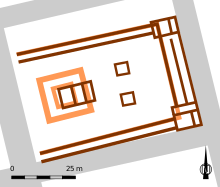
[103] To the west of the main sanctuary, across the cardo maximus, a building occupying an entire insula appears to outline a central courtyard surrounded by a gallery with porticos.
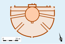
[114][115] A second cultic complex, consisting of at least one fanum-type temple surrounded by a well-identified peribolos occupying an entire insula of 3,300 m², was detected in 2020 north of the decumanus maximus towards the theater.
[116] The masonry located beneath and surrounding the foundations of the Chapel of Our Lady of Victory, situated to the south of the site, can be attributed to a large ancient structure (measuring several hundred square meters), which is believed to have been a public building comprising multiple rooms.
[118][119] Despite the presence of these unusually massive masonry remains on a high point of the site and near the cardo maximus, which would be consistent with the existence of a sanctuary, the hypothesis cannot be definitively confirmed or denied.
[124] Moreover, it is possible that mausoleums or funerary chapels may have been located along a road leading towards Bayeux, southeast of the settlement, east of a district mainly devoted to artisanal activities.
[125] Nevertheless, probable dwellings seem to have been constructed closer to the urban limit, which is contrary to the general rule that Roman city necropolises are usually located beyond the built-up perimeter.
[127][128] Additionally, numerous bone fragments (primarily from cattle, goats, and sheep in decreasing order of frequency) have been discovered in these contexts, indicating significant butchery activity.
[8] These potentially odorous or visually disruptive activities, which pose fire hazards to nearby buildings (butcheries, forges), are absent from the most densely urbanized part of the city.
[131] Despite the fragmentary nature of the excavations and test pits across the settlement, the quantity and typology of the domestic ware remains, especially pottery, allow for an assessment of the intensity of the commercial exchanges that took place in the area.
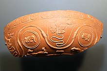
Additionally, Black Burnished ware (category 1), manufactured in Roman Britain, indicates commercial relations between Alauna and the English production sites of this type of pottery in Dorset.
These structures are likely associated with artisanal or commercial activities.Jeanne The existence of these diverse habitats has been corroborated in at least eight insulae situated to the west, east, and south of the monumental center (comprising a large sanctuary and forum).
[141] In 2020, a residential or mixed-use district integrating artisanal activities was identified at the supposed southern margins of the settlement, near the chapel of Notre-Dame de la Victoire.