Albany, New Zealand
Albany (/ˈælbəni/ ⓘ AL-bə-nee)[3][4][5] (Māori: Ōkahukura) is one of the northernmost suburbs of the contiguous Auckland metropolitan area in New Zealand.
Albany is found at the headlands of Lucas Creek, and was the location of a portage used by Tāmaki Māori, where waka could be taken between the Upper Waitematā Harbour and the Okura River/Hauraki Gulf.
During the 1840s, early European settlers established the village of Lucas Creek, which by the 1880s had become a major fruit growing centre in Auckland.
[21] The highest point in the suburb is along Corban Avenue, which reaches a height of 56 metres (184 ft) above sea level.
[23][24] Some forest remnants can be found around Albany, such as the Fernhill Escarpment, which includes tōtara trees estimated to be 800 years old.
[27][28] The North Shore was settled by Tāmaki Māori, including people descended from the Tainui migratory canoe and ancestors of figures such as Taikehu and Peretū.
[31] The poor clay soils of the area were not suitable for Māori traditional gardening techniques,[15] but the creek was a good source for eels, crayfish and flounder.
[32] An ara (traditional path) connected Lucas Creek and the Ōkura River to the north, which led to Long Bay and the upper Hauraki Gulf.
This was used as a portage, where waka could be hauled overland between the two bodies of water,[14] Numerous archaeological sites are found on the banks of the Lucas Creek and the Ōteha valley, because of its importance as a transportation node,[14][33] which follows the ridge line of Lonely Track Road.
His younger son Maraeariki settled the North Shore and Hibiscus Coast, who based himself at the head of the Ōrewa River.
[38][39] By the first half of the 19th century, the mouth of the Lucas Creek to the southwest of Albany was one of the most densely settled areas of the North Shore by Tāmaki Māori peoples.
Itinerant gum diggers would scour the area for kauri resin to sell at stores, including one located at Schnapper Rock.
[23] Gradually a small settlement developed at the Lucas Creek headwaters; in 1844 three permanent residents lived here, which had increased to 24 by 1857.
[33] Most early residents of Lucas Creek came from Great Britain and Ireland,[47] with a small number arriving from Norway in the 1870s.
[33][9][3] Fruit crops were varied, and included peaches, apples, pears, plums, loquats, cherries, quince and almonds.
[3] The Albany Fruitgrowers Association formed in 1893, and became a major influencing force in the township, including the establishment of a new post office, and lobbying for road widening projects.
[7][3] In addition to these popular crops, large blackberry and strawberry farms became a major fixture of rural Albany by the early 1900s.
[7] Albany fell under the jurisdiction of the Waitemata County, a vast local government area covering West Auckland, Rodney and the North Shore.
Residents strongly objected to the actions of the county council, feeling ignored and frustrated at the lack of roading infrastructure in Albany.
[54] In 1911, the George V Coronation Hall was opened as a local community centre,[52] and operated as a venue for the annual Albany Agricultural Show.
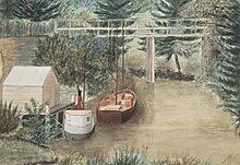
Over the next 15 years, river traffic decreased, and in 1930 the Kaipatiki ferry ceased operation,[56] and the historic Albany wharf, known as the Landing, was demolished soon after.
[57] Albany saw a population influx post World War II, including many British and Dutch migrants to New Zealand.
[58] Many new residents in Albany sought out the area in order to live on semi-rural lifestyle blocks close to Auckland.
[7] Compared to surrounding areas, most notably the East Coast Bays, growth was much slower in Albany.
[60] In 1963, the Second National Government of New Zealand requisitioned 1,500 acres (610 ha) of Albany under the Public Works Act, in order to construct state housing.
[61] Earthworks were carried out and topsoil removed, but in 1969 work stopped, and plans for the state housing area were abandoned.
[66] Strawberry and dairy farms were redeveloped into lifestyle blocks and intensive housing, beginning in the late 1980s,[67] and in 1994 the Albany Fruitgrowers Association disbanded, after operating for 100 years.
[75] On 1 August 1974, the Waitemata County was dissolved,[76] and Albany became a rural area incorporated into Takapuna City.
[81] The North Shore City council expanded Albany's parkland; in 2007, it paid $3 million for new land totalling 7,000 square metres (75,347 sq ft).
[87] Kell Park reserve next to the new Albany Village Library was known for its free-range bantam chicken population, and pirate ship flying fox playground.