Albertine Rift
[1] The Albertine Rift and the mountains are the result of tectonic movements that are gradually splitting the Somali Plate away from the rest of the African continent.
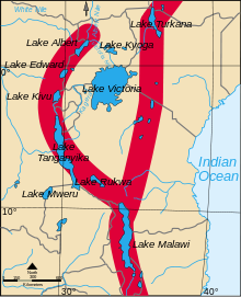
The Victoria Nile flows from Lake Victoria into the northern end of Lake Albert and exits as the White Nile from a point slightly to the west, flowing north to the Mediterranean.
[4] The Lukuga has formed relatively recently, providing a route through which aquatic species of the Congo Basin could colonize Lake Tanganyika, which formerly had distinct fauna.
[7] The Virunga Massif along the border between Rwanda and the DRC consists of eight volcanoes.
The ecology is threatened by deforestation as a growing population seeks new farmland.
Illegal timber extraction is another problem, and artisanal gold mining causes some local damage.