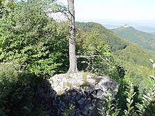
Albtrauf
Major traffic routes leading from the alpine foothills to the Albtrauf are known as the Alb ascension (German: Albaufstieg), the best known of them being the Geislinger Steige.
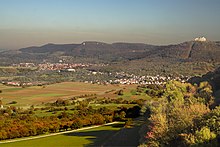
The most famous inliers and outliers without a dip slope include, from northeast to southwest, Ipf, Hohenstaufen, Achalm and Hohenzollern (Zoller).
Kaltes Feld, Michelsberg, Farrenberg, the plateau of Burgfelden (Böllat-Heersberg) and Plettenberg rank among the most impressive inliers and outliers with a dip slope.
Juniper heathland, typical of the high plains of the Swabian Alps, can also be found in scattered locations, such as on Jusi, and is generally under conservation.
[1] Spruce and fir forest can also be found in the Hohen Schwabenalb (high Swabian Alps) as a result of forestry atypical for the area.
The Schwäbische-Alb-Nordrand-Weg (Hauptwanderweg 1, HW 1), a hiking trail maintained by the Schwäbischen Albverein (Swabian Jura Association), provides access to the Albtrauf and leads from Donauwörth to Tuttlingen.