Alconétar Bridge
[1] Due to its design, it is assumed that the bridge was erected in the early 2nd century AD by the emperors Trajan or Hadrian, possibly under the guidance of Apollodorus of Damascus, the most famous architect of the time.
[2] The almost 300 m long Alconétar Bridge served as a crossing point for the Roman Via de la Plata, the most important north–south connection in western Hispania,[3] over the Tagus, the longest river of the Iberian Peninsula.
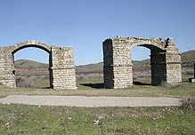
[4] During the building of the Alcántara Dam in 1970, the remains of the bridge were moved from their original site to a meadow six kilometers to the north, close to the municipality of Garrovillas de Alconétar.
[6] In the classical period, the Alconétar Bridge was part of the Roman road Iter ab Emerita Caesaraugustam, that was later called Via de la Plata.
This important inner Iberian connection led from the provincial capital Mérida in the south, through the river valleys of Alagón, Tiétar and Tagus to the north, then on to the western part of Meseta Central, passing the major town of Salamanca.
[3] The Via de la Plata was one of the four main routes which were established by Augustus (30 BC–14 AD) and his successors for military control of the peninsula and for facilitating the exploitation of the rich Spanish silver and gold mines.
[6] It also remains unknown why the bridge of Alconétar is called Puente de Mantible in the local vernacular, an expression which alludes to the legend of Charlemagne and his Twelve Paladins.
[16] On the site of the ancient way station, a fortress was erected in the Middle Ages;[17] its tower built of Roman spolia emerges from the Alcántara reservoir at low water.
[7] The reconstruction sketch produced by Rodriguez (see diagram below) shows the profile of the bridge, rising evenly and dominated by three central arches in the centre of the river.
Although this was a serious attempt to reconstruct the bridge as close to the original as possible, the Spanish scholar Durán points out that slight changes to the main body can never be avoided in the course of such a difficult undertaking.
[31] In particular, it is possible to reconstruct relatively precisely the rise of the Roman segmental arches on the basis of the angles of the inclined stone supports at the springing level.
[17] This value is supported by de Labordes' engravings which depict an intact Roman segmental arch spanning the adjoining fourth bay as late as the early 19th century.
Its existence demonstrates that, in contrast to what had previously been widely believed and taught, Roman bridge builders possessed intimate knowledge of flattened arches.
[18] The fifth and ultimate pier, which carries the distinctive nickname "Bishop's table", takes an advanced position in the riverbed and possesses by far the largest cross-section (8.10 m (26.6 ft)).