Aldermaston
[citation needed] The Anglo-Saxon Chronicle states that the first known Ealdorman of Berkshire, Aethelwulf, fought the Danes with Ethelred of Wessex at the nearby Battle of Englefield in 871.
[6]: 2 Aldermaston was held by the Achard family until the 14th century, when it passed through marriage to Thomas De La Mare of Nunney Castle, Somerset.
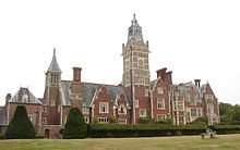
[17]: 63 The interior of the house featured a number of mythical statues,[18]: 208 as well as artwork by Gaspard Dughet, portraits of William Congreve and Godfrey Kneller, and Tintoretto's Esther Before Ahasuerus.
[19]: 104 The house's Jacobean garden featured patterns of groves and avenues of oak, yew, Spanish chestnut and lime trees.
[22]: 4 During Keyser's lordship, John Marius Wilson's Imperial Gazetteer of England and Wales listed Adminston as a possible name for the village.
[12]: 12 During the 1940s RAF Aldermaston was created on the parkland at the southern end of the parish, with the Women's Land Army and the XIX Tactical Air Command stationed on the estate.
[16]: 25 With the opening of the Atomic Weapons Research Establishment (AWRE) in 1950, Aldermaston became synonymous with a number of Campaign for Nuclear Disarmament (CND) marches.
[16]: 63 Blue Circle could not gain planning permission in the grounds of the court, so the MERLIN reactor was demolished to make way for Portland House.
With a full redevelopment of Aldermaston Manor, the £14 million office development became Blue Circle's international headquarters and the complex was opened by Prince Richard, Duke of Gloucester.
[12]: 11 The Loosey was previously home to the village maypole (which was often climbed by Daniel Burr's monkey) and a drinking fountain erected by Charles Keyser to celebrate the Diamond Jubilee of Queen Victoria.
[41][16]: 85 The flood in 1971 caused by torrential rain was exacerbated by the non-porous tarmac and buildings of the Atomic Weapons Establishment which managed for the first time to overwhelm its balancing ponds.
[16]: 85 This happened again in July 1989, when an average of 6 inches (150 mm) of rain was deposited across the parish in two hours; water rose 5 feet (1.5 m) above the ponds and broke through a brick wall.
Thames Valley Police stated that the emergency services were "really stretched because of what happened over the county and the Glade event", that "the A340 road junction was two or three-foot under water", and predicted that "a lot of householders would be homeless.
[55]: 22 Of the 70% outside the village, 30% lived at Aldermaston Wharf, 20% in the local mobile home parks, 10% in the Falcon Fields development and 10% in "other outlying areas".
[61]: 1 Gilchrist (Mathews' business partner) bought the mill from William Mount in 1856 using money inherited from his brother's death the previous year.
[61]: 2 After Keyser had died and the Aldermaston estate had been divided and sold, his widow, Mary, approached Evelyn Arlott to run the mill as a tea room and guesthouse.
[4]: 3 [64]: 48 The building has a large black and gold clock set into the gable, and a small bell turret upon which is a gilt fox-shaped weather vane.
In the British Parliamentary Papers of 1817, the Committee on the State of the Police in the Metropolis reported evidence of a John Adams—a Reading-based distiller and hop merchant—who competed for business against H & G Simonds Brewery.
[16]: 114 Old Village Farm (on Fishermans Lane) is the location of a wood yard, used since the 1930s to prepare local willow for the production of cricket bats.
[16]: 38 The wood yard was featured on A Question of Sport, when cricketer Graham Gooch took part in the programme's "Mystery Guest" round.
When he scored 333 runs against India at Lord's in the 1990 test season, the Turbo 333 bat, made from Aldermaston wood, was launched in his honour.
[79] The 50th anniversary of the event was marked on 24 March 2008 with the "Bomb Stops Here" protest, attended by Vivienne Westwood and Campaign for Nuclear Disarmament (CND) president Walter Wolfgang.
[82] Until 2005, AWE discharged "pre-treated waste water"[83] into the River Thames at Pangbourne via an 11.8-mile (19.0 km) pipeline which runs under roads and fields within the parish.
[16]: 46 Similar events took place in March 2003 when hundreds of local residents protested against an application of gravel extraction by Lafarge.
[4]: 3 In total, 51 structures in the parish are listed,[102] including gatepiers,[103] greenhouses,[104] a tomb,[105] railings and a wall,[106] the village red telephone box[a][107][106] and Aldermaston Lock.
The open auction starts with a horseshoe nail driven through a tallow candle an inch below the wick and lit in the parish hall.
A report was presented in 2009 evaluating the problems caused by HGV traffic through the village,[121]: 2 and described solutions which included support from Newbury MP Richard Benyon.
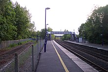
[121]: 9 The nearest operating airstrip, Brimpton Airfield, is less than 1 mile (1.6 km) west of the village, within AWE's restricted airspace.
[128] Individuals buried in the churchyard include squires Charles Keyser (1847–1929) and Daniel Burr (c. 1811–1885), schoolmaster John Stair (c.1745–1820), and Maria Hale (1791–1879).
Sir William Mount, 2nd Baronet, the grandfather of British Prime Minister David Cameron, allowed a cricket pitch to be established on a portion of his Wasing estate.


Aldermaston Village
Aldermaston Wharf
Falcon Fields
Ravenswing/Pinelands
Raghill and other outlying areas