Algeciras
The urban area straddles the small Río de la Miel, which is the southernmost river of continental Europe.
[3] The Arabic name for the settlement founded by Muslims after the conquest of the Iberian Peninsula was al-Jazīrah al-Khaḍrāʾ (الجزيرة الخضراء, "The Green Island"), in reference to Isla Verde.
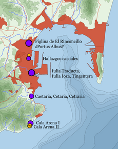
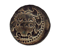
1] Algeciras' site was also that of Roman cities called Portus Albus ("White Harbor"), Caetaria (current Getares) and Iulia Traducta.
[7][8] After being destroyed by the Goths and their Vandal allies,[citation needed] the city was under the control of the Visigothic kingdom until Tarik landed in Algeciras and Tarifa in April 711.
[9] In the year 859 AD Viking troops on board 62 drekars and commanded by the leaders Hastein and Björn Ironside besieged the city for three days and subsequently laid waste to much of it.
Vowing to counter the Castilian expansion initiated by 1265, Nasrid Granada required assistance from Fez in late 1274 and ceded the place of Algeciras (together with Tarifa) to the Marinids.
[6] On winning the city, Alfonso XI made it the seat of a new diocese, established by Pope Clement VI's bull Gaudemus et exultamus of 30 April 1344, and entrusted to the governance of the bishop of Cadiz.
[14] Left relatively unguarded during the Castilian Civil War, the town was easily seized in 1369 by the Nasrids from Granada with assistance from a Marinid fleet.
[16] While tradition asserts that it was torn down immediately after the 1369 occupation, the Nasrid scorched-earth policy has been also dated to 1375, once Granadan repopulation efforts should have failed.
[17] The garrison was thus relocated to Gibraltar, with a worse port but more easily defensible, in Nasrid control after the Marinid retreat from the Iberian Peninsula.
[18] While the jurisdiction was ceded to Gibraltar in 1462 after the Castilian conquest of the latter place, there are hints about the continued existence of informal settlements by farmers and sepherds in the area, at least after 1466.
[19] Algeciras was refounded after 1704 by refugees from Gibraltar following the territory's capture by Anglo-Dutch forces in the War of the Spanish Succession.
[23] Just like the rest of the Campo de Gibraltar, husbandry (cattle in particular) played an important role in the economy during the 18th century thanks to the rich pastures.
Its strategic location near the Strait of Gibraltar—the choke point connecting the Atlantic Ocean and the Mediterranean Sea also entailing the nearest distance between Europe and the African continent—has historically powered the importance of the port.
[31] Algeciras has a Mediterranean subtropical climate (Köppen: Csa) with very mild, rainy winters and warm, dry summers with occasional heat waves, and temperature fluctuations are small because of the strong Oceanic influence.
The city also has a substantial fishing industry and exports a range of agricultural products from the surrounding area, including cereals, tobacco and farm animals.