Allegany County, Maryland
[2] The name Allegany may come from a local Lenape word, welhik hane[3][4] or oolikhanna, which means 'best flowing river of the hills' or 'beautiful stream'.
[5] A number of counties and a river in the Appalachian region of the U.S. are named Allegany, Allegheny, or Alleghany.
[7] Prior to 1789, the Virginia Commonwealth claimed the area of present-day Garrett and Allegany Counties, of Maryland.
[11] Allegany County lies primarily in the Ridge-and-Valley Country of the Appalachian Mountains.
It is bordered to the north by the Mason–Dixon line with Pennsylvania, to the south by the Potomac River and West Virginia, to the east by Sideling Hill Creek and Washington County, Maryland, and to the west by a land border with Garrett County, Maryland.
It is a strongly Republican county, the last Democrat to win a majority being Jimmy Carter in 1976.
[32] The only other Democrats to carry the county since 1880 have been Lyndon B. Johnson, Franklin D. Roosevelt (twice), and by very narrow margins Harry S. Truman in 1948 and Woodrow Wilson in 1912.
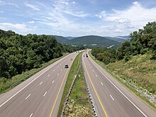
Allegany County has been, since colonial times, an important node on the nation's transportation network as a key transition point in the movement of goods and people to and from the ports of the Mid-Atlantic and the agricultural and industrial production centers of the Ohio Valley and Midwest.
The Cumberland Narrows, a naturally-occurring watergap separating Wills and Haystack Mountains, serves as one of the few passages through what is otherwise one of the steepest rushes of the Ridge and Valley province.
Because of this, Cumberland has been the site of both planned and completed transportation projects focused on connecting east and west.
On his fateful march from Alexandria to Fort Duquesne in modern-day Pittsburgh during the French and Indian War, British General Edward Braddock and his men, including then-Lieutenant Colonel and Braddock's aide-de-camp George Washington, carved a road, closely following the Native American Nemacolin's Path, from the British encampment at Fort Cumberland, through the Allegheny Mountains all the way to Fort Duquesne.
[35] A monument to the start of the National Road now stands on Greene Street in Cumberland, very near the spot Braddock and his men began their expedition.
ACPS is governed by an elected, five-member Board of Education, plus an appointed superintendent.
ACM also operates a satellite campus in Everett, Pennsylvania, about 30 miles north of Cumberland in Bedford County.
[40] The primary mineral resources extracted for use in Allegany County are coal, iron, sandstone, and limestone.
Coal-bearing formations are concentrated in the Georges Creek Basin in the western part of the county.
Here is a reference that it existed (the letter symbols at the end of the reference are defined in a table at the end of Keegan's book) A Third Rutan Family Index p 177 By James J. Keegan Maryland Listings: Peter Rutan - (1776-1848_ p/John Rutan-Catherine Jones of Morris Co. NJ; m (1) Elizabeth McIlrath (1771–1845) (2) Mary Webb (1788–1855) in 1846; he was living in Sandy Creek, Allegany Co. in 1880 and moved to Markleysburg, Fayette Co. PA in 1812; they later (lived) in Caroll Co. OH; GSNJ; LDS; MEACH