Garrett County, Maryland
[2] The county was named for John Work Garrett (1820–1884), president of the Baltimore and Ohio Railroad.
[4] The eastern border with Allegany County was defined by the Bauer Report, submitted to Governor Lloyd Lowndes, Jr. on November 9, 1898.
Hoye-Crest, a summit along Backbone Mountain, is the highest point in Maryland at an elevation of 3,360 feet (1,020 m).
The extreme south of the county lies within the United States National Radio Quiet Zone.
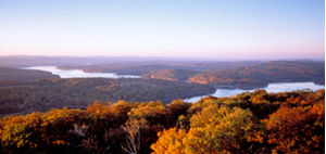
Today, tourism has made a dramatic rebound in the county with logging and farming making up the greatest part of the economic base.
Due to a cool climate and lack of any large city, Garrett County has remained a sparsely populated rural area.
[9] As is typical in the Allegheny region, broad flats generally lie below the ridge crests at elevations of approximately 500 feet (150 m).
River valleys are generally narrow and deep, with ravines typically 1,000 to 1,800 feet (550 m) below surrounding peaks.
The Casselman River, a tributary of the Youghiogheny, flows north from the county's central section into Pennsylvania.
The Youghiogheny itself drains the westernmost area of the county and flows north into Pennsylvania, where it empties into the Monongahela River at McKeesport, just south of Pittsburgh.
[10] The Glades' 601 acres (2.43 km2) is of great scientific interest because it is an ombrotrophic system (fed solely by rainwater) with peat layers up to 9 feet (2.7 m) thick, and is one of the oldest examples of mountain peatland in the Appalachians.
[11] On the western edge of the Savage River State Forest along Maryland Route 495 lies Bittinger, Maryland, which is named after Henry Bittinger, who first settled in the area and who was joined by other German settlers moving in and taking up the fertile farmland.
A series of low mounds can be seen in the fields on the west side of Maryland Route 495 that are "loess" (wind-blown) material.
Wind blew fine grains of earth into the water around the edges where it sank to the bottom, and the mounds were the result of the deposit of this wind-blown material.
Popular activities in the county include camping, hiking, backpacking, rock climbing, alpine and cross-country skiing, snowmobiling, hunting, ice fishing, fly fishing, whitewater canoeing, kayaking, rafting, boating, swimming, sailing, horseback riding, and water skiing.
All offer picnic and fishing areas; all but Casselman River State Park have hiking paths.
Mountain bike paths, swimming areas, and boat launches and rentals are available at Deep Creek, Herrington Manor, and New Germany state parks.
Big Run, Deep Creek, Herrington Manor, and New Germany state parks all offer canoeing, while campsites may be found at Big Run, Deep Creek, New Germany, and Swallow Falls state parks.
The recreation areas are attached to public schools and colleges and maintained by the Garrett County Board of Education.
[19] The municipal parks of Garrett County provide sport facilities, hiking, bike and walk paths, playgrounds, picnic areas, boat ramps, and fishing.
Since then, an additional four branches have been added to the library system in Accident, Friendsville, Grantsville, and Kitzmiller.
Although since the Civil War Maryland has been a Democratic-leaning state, Garrett County, owing to its history of German settlement from north of the Mason–Dixon line, plus strong pre-war Unionism resulting from virtual absence of slaves,[37] has always been strongly Republican.
Since it was created in 1872, Garrett is one of forty counties across the nation (chiefly Unionist strongholds in antebellum slave states) to have never voted for a Democratic presidential candidate.
Owing to its strong Republican lean, Garrett County sometimes votes against ballot measures that the rest of the state approves by large margins.
During the Covid-19 Pandemic, tourism boomed as many people from Washington, DC, Baltimore, and Pittsburgh wanted to get away from the city.
The airport enhances the region's tourist industry and provides emergency air service evacuation and landing facilities for general aviation.
The United States Census Bureau recognizes seven census-designated places (CDPs) in Garrett County.
The following communities are classified as populated places or locales by the Geographic Names Information System.