Alsta
The island is surrounded by the Vefsnfjorden to the east, the Leirfjorden to the north, and the Alstenfjorden to the south and west.
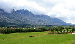
The eastern part of the island is dominated by the Seven Sisters mountain range (Norwegian: De syv søstre) which has five mountains that are more than 1,000 metres (3,300 ft) tall, while the western part of the island is relatively flat and it is the location of the town of Sandnessjøen and the village of Søvika in the south.
[2][1] The 30-kilometre (19 mi) long island has an area of 152.6 square kilometres (58.9 sq mi), and its highest point is the mountain Botnkrona, which reaches 1,072 metres (3,517 ft) above sea level.
[2] The islands of Altra and Skålværet lie to the southwest, the islands of Tjøtta, Offersøya, Mindlandet, and Rødøya lie to the south, surrounding the entrance to the Vefsnfjorden.
The island is connected to the mainland by the Helgeland Bridge on Norwegian County Road 17, which connects the northern part of the island to Leirfjord Municipality on the mainland.