Amchitka
Amchitka was selected by the United States Atomic Energy Commission (AEC) to be the site for underground detonations of nuclear weapons.
[3][4] The tests were highly controversial, with environmental groups fearing that the Cannikin explosion, in particular, would cause severe earthquakes and tsunamis.
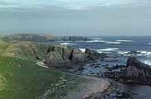
[5]: 3 There is low but abundant vegetation,[5]: 3 consisting of mosses, lichens, liverworts, ferns, grasses, sedges, and crowberry.
[7] Geologically, the island is volcanic, being a part of a small crustal block on the Aleutian Arc that is being torn apart by oblique subduction.
[13] Eager to remove the Japanese, the Joint Chiefs of Staff agreed to move quickly to regain the territory.
American planners decided to build a series of airfields to the west of Umnak, from which bombers could attack the invading forces.
[14] At the War Department's suggestion, an initial reconnaissance of Amchitka was carried out in September 1942, finding that it would be difficult to build an airstrip on the island.
[13] A further reconnaissance mission visited Amchitka from 17 to 19 December, and reported that a fighter strip could be built in two to three weeks, and a main airfield in three to four months.
[14] The military eventually built numerous buildings, roads, and a total of three airstrips on the island,[15] one of which would later be rebuilt and used by the Atomic Energy Commission in the late 1960s.
[20] The site later hosted an Air Force White Alice Communications System from 1959 to 1961, and a temporary relay station in the 1960s and 1970s.
[23] With the pullout of military forces from Amchitka in 1950, the Department of Defense (DoD) initially considered the island for nuclear testing planned for 1951, under Operation Windstorm.
[25] The 1.7-kiloton (7.1 TJ) Rainier test (part of Operation Plumbbob, performed in Nevada) produced strong seismic signals, but looked much like an ordinary earthquake.
[27][28] To conduct the Vela Uniform test Long Shot,51°25′35.84″N 179°11′14.13″E / 51.4266222°N 179.1872583°E / 51.4266222; 179.1872583 the Department of Defense occupied Amchitka from 1964 to 1966, with the AEC providing the device, measuring instruments, and scientific support.
After the devastating Great Alaska earthquake of March 27, 1964, the governor expressed concern about the psychological effects of the test on the populace.
"[32] It was a "calibration shot", intended to produce data from which the impact of larger explosions could be predicted, and specifically, to determine whether the planned Cannikin detonation could be performed safely.
[34] The blast "turned the surrounding sea to froth" and "forced geysers of mud and water from local streams and lakes 50 feet (15 m) into the air".
"[36] A few days after the Milrow test, the Don't Make A Wave Committee was organized at a meeting in Vancouver, British Columbia, Canada.
Russell Train, then Chairman of the Council on Environmental Quality, argued that "experience with Milrow ... does not provide a sure basis for extrapolation.
"[39] In July 1971, a group called the Committee for Nuclear Responsibility filed suit against the AEC, asking the court to stop the test.
[40] The suit was unsuccessful, with the Supreme Court denying the injunction by 4 votes to 3,[41] and Richard Nixon personally authorized the $200 million test, in spite of objections from Japan, Peru, and Sweden.
[31] In 2004, scientific divers from the University of Alaska Fairbanks collected shallow subtidal organisms[47] and reported that "There were no indications of any radioactive leakage, and all that was really wonderful news.