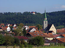
Ammerbuch
The name Ammerbuch is a portmanteau of the two locations between which the municipality is situated — Ammer Valley and the Schönbuch nature park.
The former municipal coat of arms shows in gold (yellow) a rooted green beech, covered with a lowered blue wave beam.
Tools, huts and tombs have been found on the Kirchberg in Reusten, and their age is estimated to be about 6,000 years.
Ammerbuch is located between the Ammer Valley and the Schönbuch nature park in the Gäu, a geological region dominated by keuper, gypsum and sandstone layers.
[7] In the mayoral election on 16 February 2014, the former councilor Christel Halm (CDU) continued through with 50.9% in the second ballot against four competitors.
[9] On 22 July 2013, the predecessor Friedrich von Ow-Wachendorf informed the council that he would retire 31 March 2014 for personal reasons from his office.
[10] Ammerbuch is dominated by pleasantly mild climate, in some places part-time winemakers grow grapes.
The Bundesstraße 28 connects the town to the west with Herrenberg, and then to the A81 and to the east with Tübingen, Reutlingen and Ulm.
The Ammer Valley Railway runs from Tübingen to Herrenberg through the municipality with breakpoints in Pfäffingen, Entringen and Altingen.
In Tübingen it provides connections to Reutlingen, Metzingen and Nürtingen, Wendlingen and Stuttgart or to Rottenburg and Hechingen).