Department of Ancash
Ancash (Quechua: Anqash; Spanish: Áncash pronounced [ˈaŋkaʃ]) is a department and region in western Peru.
It is bordered by the departments of La Libertad on the north, Huánuco and Pasco on the east, Lima on the south, and the Pacific Ocean on the west.
Also along the Pacific slopes, the Santa River has shaped a wide valley in the punas which narrows into the Cordillera Negra, where the Cañón del Pato canyon was formed.
[3] However, when warmer waters from the north, such as the current of El Niño, bring catastrophic rains to the coast and sea, the shoals of anchoveta disappear, leaving the fishing fleets plants paralysed, and flooding rivers cause serious damage to the lands and cities.
The coastal region of Peru includes many peninsulas, creeks, warm bays and sand beaches, full of colour.
Much of this coast is a monotonous stretch of huge sand deserts, a common denominator in all Peruvian coastal regions because of the influence of the Humboldt Current.
From south to north, the main rivers of the Ancash coast are the following: Huarmey, Culebras, Casma, Sechín, Nepeña, Lacramarca and Santa.
Though in the Colonial Age this city held little importance and its artistic and cultural life did not have much relevance, it became the headquarters for Simón Bolívar during his campaign to liberate Peru.
The 1970 Ancash earthquake devastated the department, killing more than 50,000 people and damaging 186,000 houses in one of the deadliest natural disasters in Peru.
Beginning in 2011, the department has been the site of an ongoing anti-mining protest over allegations of water contamination and public versus private rights to the natural resources of the zone.
Clashes between protesters, mining company security, and the federal police have resulted in numerous deaths and injuries.
The provinces and their capitals are: The economy of Ancash, the third largest in Peru, is largely made up of gold, copper and zinc mining.
According to Article 20 of Decreto Supremo No 004-2016-MC (Supreme Decree) which approves the Regulations to Law 29735, published in the state-owned newspaper El Peruano on 22 July 2016, adequate spellings of the toponyms in the normalised alphabets of the indigenous languages must progressively be proposed with the aim of standardizing the namings used by the National Geographic Institute (Instituto Geográfico Nacional, IGN).
[7] Contrarily to intentions to replace indigenous toponyms by other names like Santa Cruz or Contrahierbas, the Ministry of Culture proposes to the municipalities of the provinces to recover ancient indigenous toponyms and that these names should be spread by the local and communal authorities on posters and other signage.
[7] The geographical centre of Ancash, the Callejón de Huaylas, is an area of intense interest to tourists.
This is due to its large variety of natural attractions, its sport and recreational facilities, and the nearby archaeological remains of the ancient cultures that once flourished there.
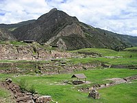
[citation needed] Among archaeological sites of interest, Ancash has many vestiges of old cultures, including the Guitarrero Cave (10,000 BC), the pre-Columbian ruins of Chavín de Huantar, Hunsakay, Willkawayin, Sechín, and Pañamarka are also well-known.
This road is completely paved, although it often had to be repaired because of the extreme damage caused by the huaycos (flash floods) and the rains.
This highway is 287 kilometres (178 mi) long, with an extremely comfortable course, especially in the steep climbing stretches through the Cordillera Negra (Black Range) up to the summit of Conococha, 4,100 metres (13,451 ft) above sea level.
This mountain range was called White, not only for its eternal snow but also for the chemical constitution of its quartz and feldspar rocks.
It has the highest summit in Peru and the fifth one in America after Aconcagua, Ojos del Salado, Bonete and Mercedario: Huascarán, whose south peak reaches 6768 msnm.
Huascarán's north peak reaches 6655 m. Alpamayo whose height has been estimated in 5,947 m, has been considered as "the most beautiful snow mountain of the world".
This statement was achieved by the distinguished Peruvian mountaineer César Morales Arnao who sent the photo of Alpamayo to the world contest of scenic beauty made in 1966 in Munich, Germany.
This National Park includes parts of the following provinces: Recuay, Huaraz, Carhuaz, Yungay, Huaylas, Pomabamba, Mariscal Luzuriaga, Huari, Corongo, Sihuas and Bolognesi.
In its fauna, there are tarucas, spectacled bears, vicuñas, pumas, foxes, vizcachas, weasels, Andean mountain cats, opossums, hog-nosed skunks, etc.
It can be seen small rural districts with chacras (smallholdings) that have been sown with potatoes, wheat, barley and other food products.
Extreme sports in the Callejón de Huaylas and the Huascarán National Park: From Chimbote to Huallanca, there are approximately 140 km (87 mi).
In this place, the waters turn into whirlpools and rapids before going out from a narrow gorge of 500 m that is called Cañón del Pato (Duck Canyon).
This waterfall constitutes the source of hydroelectric energy in the power station of the Cañón del Pato, in Huallanca.
The topography of the soil presents high summits, deep valleys and inhospitable punas, making it a rough zone, such as most of the highland in Peru.