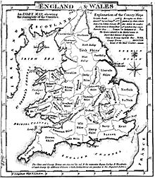
Historic counties of England
The historic counties of England are areas that were established for administration by the Normans, in many cases based on earlier kingdoms and shires created by the Angles, Saxons, Jutes, Celts and others.
[7] In the centuries that followed their establishment, as well as their administrative function, the counties also helped define local culture and identity.
[11][12] Unlike the partly self-governing boroughs that covered urban areas, the counties of medieval England existed primarily as a means of enforcing central government power, enabling monarchs to exercise control over local areas through their chosen representatives – originally sheriffs and later the lord-lieutenants – and their subordinate justices of the peace.
[13] Counties were used initially for the administration of justice, collection of taxes and organisation of the military, and later for local government and electing parliamentary representation.
[14] The majority of English counties are in the first category, with the name formed by combining the central town with the suffix "-shire", for example Yorkshire.
In most cases, these consist of simple truncation, usually with an "s" at the end signifying "shire", such as "Berks" for Berkshire or "Bucks" for Buckinghamshire.
The areas that would later form the English counties started to take shape soon afterwards, with the Kingdom of Kent founded by settlers around 445.
[14] Later earldoms were created that were not named after a shire, particularly from the 17th century onwards, but by that time the title of earl was honorary, with no effective role in local administration.
[25] Each shire was responsible for gathering taxes for the central government; for local defence; and for justice, through assize courts.
Only one county on the south coast of England now usually takes the suffix "-shire": Hampshire, named after the former town of "Hamwic" (sic), the site of which is now a part of the city of Southampton.
[29] Devon and Cornwall were based on the pre-Saxon Celtic tribes known in Latin as the Dumnonii and Cornovii, in the latter case with the suffix wealas, meaning foreigners, added by the Saxons.
When Wessex annexed Mercia in the 10th century, it subdivided the area into various shires of roughly equal size and tax-raising potential or hidage.
[30] In the east Midlands, it is thought that county boundaries may represent a 9th-century division of the Danelaw between units of the Danish army.
Lincolnshire was the successor to the Kingdom of Lindsey, and took on the territories of Kesteven and Holland when Stamford became the only Danelaw borough to fail to become a county town.
For legal purposes it was regarded as part of England, but Laws since the late 19th century were often applied to "Wales and Monmouthshire".
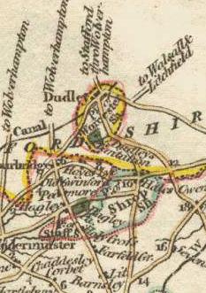
Bristol developed as a major port in the medieval period, straddling both sides of the River Avon which formed the ancient boundary between Gloucestershire and Somerset.
[48] Charters granting separate county status to the cities and boroughs of Chester (1238/9), York (1396), Newcastle upon Tyne (1400) and Kingston-upon-Hull (with the surrounding area of Hullshire) (1440).
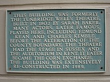
Several towns are historically divided between counties, including Banbury, Burton upon Trent, Newmarket, Peterborough, Royal Tunbridge Wells, Royston, Stamford, Tamworth, Todmorden, Warrington and Wisbech.
In Newmarket and Tamworth the historic county boundary runs right up the middle of the high street; in Royal Tunbridge Wells the historic county boundary had a theatre (now the Corn Exchange) built right on it, with the actors playing in Sussex to an audience in Kent; and in Todmorden, the historically fractious border between Lancashire and Yorkshire (the river known as Walsden Water) had Todmorden Town Hall built right on top of it on a culvert tunnel, dividing the hall down the middle between the two counties – a division reflected in its architecture.
In May 2010 Postcomm announced that it was encouraging Royal Mail to discontinue the use of counties in its alias file at the earliest opportunity.
A review of the structure of local government in England by the Local Government Commission for England led to the restoration of the East Riding of Yorkshire, Herefordshire, Rutland and Worcestershire as administrative areas in the 1990s; the abolition of Avon, Cleveland and Humberside within 25 years of their creation; and the restoration of the traditional borders between Somerset and Gloucestershire (except at Bristol), County Durham and Yorkshire (towards the mouth of the River Tees; not in Teesdale), and Yorkshire and Lincolnshire for ceremonial purposes in these areas.
It states that the "...ABC contends that Britain needs a fixed popular geography, one divorced from the ever changing names and areas of local government...The ABC, therefore, seeks to fully re-establish the use of the historic counties as the standard popular geographical reference frame of Britain and to further encourage their use as a basis for social, sporting and cultural activities.
Their objectives are:[71] In 2013, Secretary of State for Communities and Local Government Eric Pickles formally recognised and acknowledged the continued existence of England's 39 historic counties.
They have removed, resorted or erected a number of what they claim to be "wrongly sited" county boundary signs in various parts of England.
During the 19th century penal reformers campaigned against the often primitive conditions in gaols, and under the Prison Act 1877 they came under Home Office control.
The lieutenants had a military role, previously exercised by the sheriffs, and were made responsible for raising and organising the militia in each county.
[86] The Cardwell and Childers Reforms of the British Army linked the recruiting areas of infantry regiments to the counties.
By the 19th century the county magistrates were exercising powers over the licensing of alehouses, the construction of bridges, prisons and asylums, the superintendence of main roads, public buildings and charitable institutions, and the regulation of weights and measures.
Each "place" included in the IPN is related to the historic county it lies within, as well as to a set of administrative areas.
Wulfric's estates remained grouped together after his death, when they were left to his brother Ælfhelm, and indeed there still seems to have been some kind of connexion in 1086, when south Lancashire was surveyed together with Cheshire by the Domesday commissioners.