Anderlecht
Located in the south-western part of the region, it is bordered by the City of Brussels, Forest, Molenbeek-Saint-Jean, and Saint-Gilles, as well as the Flemish municipalities of Dilbeek and Sint-Pieters-Leeuw.
At that time, this community was already home to a chapter of canons[4] and to two feudal manors, those of the powerful lords of Aa and of Anderlecht.
[5] In 1356, the Count of Flanders, Louis II, fought against Brussels on the territory of Anderlecht, in the so-called Battle of Scheut, supposedly over a monetary matter.
[6] Although he defeated his sister-in-law, the Duchess of Brabant, Joanna, and briefly took her title, she regained it the following year with the help of the Holy Roman Emperor, Charles IV.
By the end of the 18th century, Anderlecht including its dependencies, which extended to Brussels' city walls, counted around 2,000 inhabitants.
Remarkable new urban developments and garden cities such as La Roue/Het Rad, Moortebeek and Bon Air/Goede Lucht were built at the beginning of the 20th century to house the influx of newcomers.
Following World War II, some remaining green parts of the municipality also made way for large-scale urban renewal following the modernist Athens Charter and Park system, such as the housing projects Scherdemael, Peterbos and Marius Renard in the upper town, and Aurore near the canal.
Anderlecht, in common with the rest of Brussels, experiences an oceanic climate (Köppen: Cfb) with warm summers and cool winters.
The territory of Anderlecht is very heterogeneous and is characterised by a mixture of larger districts including smaller residential and (formerly) industrial neighbourhoods.
It developed during the Industrial Revolution along the Brussels–Charleroi Canal and is currently in a fragile social and economic situation due to the decline of its economy and the poor quality of some of its housing.
[22] Located in the south of Anderlecht, La Roue/Het Rad ("The Wheel") is one of the municipality's largest districts and one of Brussels' main garden cities.
It is in this district, on the Chaussée de Ninove/Ninoofsesteenweg, that lay the foundations of the Scheutveld College, on 28 April 1863, by the Catholic priest Theophile Verbist.
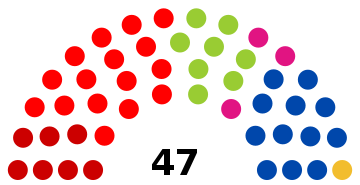
[41] The current mayor of Anderlecht is Fabrice Cumps, a member of PS, who alongside the other parties on their list, sp.a and cdH, is in coalition on the municipal council with Ecolo - Groen, DéFI and Forward.
The Abattoirs of Anderlecht [fr], located at 24, rue Ropsy Chaudron/Ropsy Chaudronstraat in Cureghem, is the main slaughterhouse in Brussels, employing some 1,500 people.
[43] In recent years, several major international companies have set up their headquarters in Anderlecht, notably the Delhaize Group, which operates many supermarket chains, from 40, Marie Curie Square,[44] Coca-Cola Benelux at 1424, Chaussée de Mons/Bergensesteenweg,[45] as well as the Belgian chocolate company Leonidas at 41, Boulevard Jules Graindor/Jules Graindorlaan.