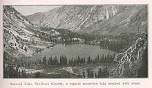
Aneroid Lake
[3][4][5] Located at the southern foot of Bonneville Mountain the lake and its basin form the headwaters of the East Fork Wallowa River.
[7] Because the lake is within the boundaries of the Eagle Cap Wilderness protection area it is inaccessible by any motorized vehicle or any other mechanized mode of travel.
[10] M. G. Royal, then president of the Weston Normal School,[11] had camped in the area on a lecturing visit in 1893 and made an excursion to the lake with his family.
This name was not recorded in any more official manner than the inscribing of it on the flattened side of a tree limb and hammered into the ground at the shore's edge.
[10] In the summer of 1897 Hoffman Philip was a member of an exploration expedition of the United States Commission of Fish and Fisheries that visited the nearby Wallowa Lake and collected specimens.
[16] Charley's residence at the lake, a two-story cabin with the lower portion being his general store offering unabashedly over priced goods and items.
The East Fork Wallowa River Trailhead is by far a shorter hike to Aneroid Lake, being only 6 miles (9.7 km) long.
After about 2 miles (3 km) of hiking on the East Fork Wallowa River Trail, the climber will reach a small dam.
It takes 2 years for these fish to grow to the legal harvest length of 8 in (20 cm) provided they survive the rest of the challenges of a high altitude lake.
[24] The Eagle Cap Wilderness has many mountainous peaks and valleys with steep slopes and precipitous windswept ridges all with a high accumulation of yearly snowfall that begins as early as October.
[28] The early spring irregular and unpredictable weather patterns at the upper elevations makes the area well known as a high risk zone for a sudden avalanche that begins without warning and instantly amasses an unstoppable force of snow and debris that swallows anything in its path.
There are two known and recorded avalanche incidents, both caused by human activity, that resulted in the loss of life in the Aneroid Lake basin.
[36] The same year as the wooden dam, Pacific Power and Light Company constructed a hydroelectric plant at the foot of the lake and installed its draw pipe pulling fifteen cubic feet per second of water to generate electricity.
[39] Wallowa County was initially responsible for obtaining the data from sampling the snow depth, determining water content and metering stream flows but when it began to feel budget constraints the program was defunded.
The Associated Ditch Companies knew they had to have the information to accurately estimate how much water will be coming into the reservoir when the spring melt begins and volunteered to assume the responsibilities for doing so in 1933.
[40] Because Aneroid Lake is located within a protected area[e] surveyors could not take advantage of the continuing advances in over-snow travel machinery.
It has a wood stove, a table and a concrete frost-proof cabinet for the supplies brought by pack train in early October each year making the trips for surveyors much more frequent and the quality of the data was vastly improved.
[40] The federal government began to take a serous interest in snow surveys and water supply forecasting after the drought of 1934 came with shadows of The Great Depression still lingering.
It was to create a network of snow courses, establish the routine and procedure of surveys, and compile the data into a forecast for each of the western states.
[44] The treks to the Aneroid station in the winter and early spring months to survey the snow pack were continued until the development of Meteor Burst Radio technology.
The SNOTEL network has the ability to bounce a radio wave off ions in the atmosphere left there by sand grain sized meteors burning up as they enter.