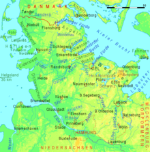
Angeln
[1] Angeln is one of four peninsulas lining the Baltic coast of Schleswig-Holstein, along with Schwansen, Danish Wahld and Wagrien.
Schleswig-Holsteinisches Moränenhügelland), formed during the Weichselian glaciation, these peninsulas are hilly and dotted with several glacial lakes.
The River Treene, with its main headstreams, Bondenau and Kielstau, rises in Angeln before flowing westwards to join the Eider, the historic border between the Danish and German realms.
The northernmost part of Angeln is the Holnis [de; da] peninsula, which projects into the Flensburg Firth.
This region represents a transition zone between the Angeln Uplands to the east and the Schleswig Geest to the west.
The Bundesautobahn 7 runs along the western edge of Angeln, connecting Schleswig and Flensburg, before merging into the Danish Sønderjyske Motorvej [da].
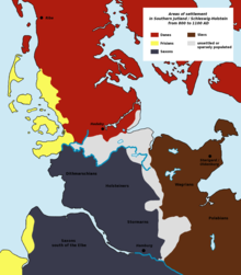
Before the 9th century Angeln was inhabited by the Angles, who spoke a West Germanic dialect that would later evolve into English.
Many Angeln place-names are of Danish origin, including those ending in -by (town), such as Brodersby, Nieby and Husby, and -rup (hamlet), such as Sörup, Sterup and Tastrup.
The region was home to the Germanic Angles, some of whom, together with Saxons and Jutes, left their homeland to migrate to the island of Great Britain in the 5th and 6th centuries.
This inconspicuous body of water is an important archaeological site and was a Germanic sacrificial bog from the times of the Roman Empire.
Whilst it is possible that the early-medieval Danish settlers did worship Thor, the name is more likely to be traced back to a hill with a Viking-Age burial ground and finds, the Thorsberg.
The settlement density in Angeln apparently decreased dramatically in the 5th and 6th centuries and many villages fell into disrepair.
Since more pollen was found at some locations of the Schleswig Geest (the region neighbouring Angeln), it is assumed that the climate had changed.
This initially regional migration would also explain another phenomenon: it is now considered likely that between the end of the settlement period of the Angles in Angeln and their arrival in eastern and central England up to 100 years passed.
For the years 449–455 the Anglo-Saxon Chronicle, written around 890, describes how Vortigern, a British king, invited the Angles to come and receive land in return for helping him defend his realm against marauding Picts.
This account can be related to the evidence of archaeology, notably the distribution of types of fibulae, or brooches, worn by both men and women in antiquity.
The unofficial coat of arms of Angeln was designed by Hans Nicolai Andreas Jensen and appeared for the first time in 1847.