Portage Glacier Highway
After about 1.2 miles (1.9 km), the roadway intersects a small gravel road that leads to the Moose Flats Day Use area, which has access to several scenic hiking trails.
The highway passes through a low-lying wetland before reentering forest and providing access to the Alder Pond Day Use area and the Portage Valley RV park.
[2][9] Portage Glacier Highway continues southeastward, providing access to the Black Bear Campgrounds, maintained by the USFS.
[8] The road continues for a short distance before passing the Begich, Boggs Visitor Center and associated buildings, comprising the headquarters of Portage Glacier unit of the Chugach National Forest.
The route proceeds on to a 0.5 mi (0.8 km) portion of road known as the "Rock Cut at Portage Lake" by the Alaska Department of Transportation & Public Facilities (DOT&PF).
This road passes along the coast of Portage Lake,[12] and borders a large, man-made cliff to the north (hence the name "Rock Cut").
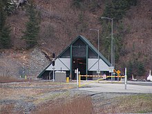
The highway continues to the six-lane Bear Valley Staging area, and the toll booth for the Anton Anderson Memorial Tunnel.
The floor of the tunnel is constructed of 1,800 texturized concrete panels, each 7.5 by 8 feet (2.29 by 2.44 m), with the railroad tracks sunken slightly below the road surface.
[14] There are two backup generators to ensure that the computerized traffic controls and safe-house ventilation systems in the tunnel continue to function in the event of a power failure.
These systems control the timing of vehicles entering the tunnel, spacing them for safety, and lower railroad gates when a train is approaching.
[21] Running parallel to the Alaska Railroad line, the route - now named West Camp Road - continues between the Passage Canal and several mountains for approximately 0.5 miles (0.80 km).
The road continues along Passage Canal for a short distance, while traveling towards the Alaska Marine Highway (AMHS) pier.
[33][35] Russian fur traders and early settlers continued to use the valley, establishing a trail along the creek and the Portage and Burns glaciers.
Less than a week after the announcement of the plan, surveying of the area around Whittier was taking place in order to make sure of the safety of building the railroad terminal.
In June 1942, Japanese forces attacked and invaded the Alaskan islands of Attu and Kiska, again provoking the need to complete the tunnels sooner.
In addition to the state's paving of the highway, the Alaska Railroad began offering shuttle services between Portage and Whittier in the mid-1960s.
The Alaska Railroad would allow vehicles to drive onto flatcars, which would then be transported by train through the Anton Anderson Memorial Tunnel to Whittier.
In preparation for the highway, Anchorage businessman Pete Zamarello purchased the Buckner Building, and planned to convert it into a resort.
In November 1995, an environmental impact statement, created by HDR Alaska, was approved by the Federal Highway Administration, allowing the project to proceed.
Then-governor of Alaska Tony Knowles began the construction when he detonated six pounds of explosives located on Begich Peak, although this was unrelated to the project.
James Keith Singleton, Jr., the district judge overseeing the case, ruled in favor of Armbrister and the Federal Highway Administration and stated that the agency was correct in its decision against improved rail service.
The court upheld Singleton's decision, finding that the project only affected a very small amount of parkland and that the road was necessary to meet the requirements for a link to the city.
These rulings were legally significant as they appeared to overturn the precedent established in the Overton Park case, which was interpreted as saying that "it must be shown that the implications of not building [a] highway pose an 'unusual situation'".
The structure was designed so that it would appear to fit with the environment but could also withstand the regular seismic activity of the region and have a minimal impact on the surrounding fish and plant populations.
[60][61] CH2M Hill was selected to design the approximately 1.5 miles (2.4 km) of highway that would connect the existing road to the Anton Anderson Tunnel.
[40][42] The Kiewit Construction Company, based in Omaha, Nebraska, was awarded the contract for phase two, redesigning the Anton Anderson Tunnel.
Beginning from the western entrance, Kiewit drilled away several feet of the rock face from the top of the tunnel and installed a net to prevent any potential rockfalls.
While that was being completed, some crews installed a series of anti-icing insulation panels and drainage pipes to keep the tunnel clear during winter months.
The town government also approved of several long-term changes to the city that would begin after the road was opened, including a second harbor, a bicycle trail, a new sidewalk system, and shopping center.
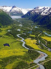
The route follows the Portage Glacier Highway for approximately 5 miles (8.0 km), passing several park campgrounds and scenic turnouts.