Appalachian Trail
[15] In 1922, at the suggestion of Major William A. Welch, director of the Palisades Interstate Park Commission, his idea was publicized by Raymond H. Torrey with a story in the New York Evening Post under a large headline reading "A Great Trail from Maine to Georgia"[16][17] On October 7, 1923, the first section of the trail, from Bear Mountain west through Harriman State Park to Arden, New York, was opened.
[20] Anderson's efforts helped spark renewed interest in the trail, and Avery, who led the project after Perkins's death in 1932, was able to bring other states on board.
[27] In 1936, a 121-day Maine to Georgia veteran's group funded and supported thru-hike was reported to have been completed, with all but three miles of the new trail cleared and blazed, by six Boy Scouts from New York City and their guides.
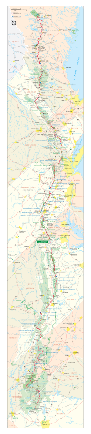
[citation needed] The International Appalachian Trail is a 1,900-mile (3,100 km) extension running northeast from Maine into New Brunswick and Quebec's Gaspé Peninsula, where it ends at Forillon National Park.
[43] Other branches are designated in parts of Nova Scotia, Prince Edward Island, and along the western shore of Newfoundland, to the northern end of the Appalachian Mountain range, where it enters the Atlantic Ocean, near L'Anse aux Meadows National Historic Site.
Promoters of the Southern extension refer to MacKaye's statement at the 1925 conference that the Georgia to New Hampshire trail should, in the future, extend to Katahdin, and "then to Birmingham, Alabama".
As of March 2015[update], The Pinhoti Trail terminates at the base of Flagg Mountain, near Weogufka in Coosa County, 50 miles (80 km) east of Birmingham.
[48] The 8.8-mile (14.2 km) Appalachian Approach Trail in Georgia begins at Amicalola Falls State Park's visitor center and ends at Springer Mountain.
[54] Other large mammals commonly sighted include deer;[55] elk, reintroduced in the Smoky Mountains; and moose, which may be found in the vicinity of Massachusetts and northward.
[55] While the vast majority of lowland forest south of the White Mountains is hardwood, many areas have some coniferous trees as well, and in Maine, these often grow at low elevations.
Farther north, several peaks in Vermont reach into the subalpine zone, the bottom of which steadily descends as one proceeds northward, so that by the White Mountains in New Hampshire, it often occurs well below 3,000 feet (910 m).
In the Presidentials, the trail climbs as high as 6,288 feet (1,917 m) on Mount Washington and spends about 13 miles (21 km) continuously above treeline, in the largest alpine environment in the United States east of the Rocky Mountains.
[62] These small rocks, which are the result of erosion that has worn away the dirt along the trails, can be tough to walk on for extended periods of time without proper hard-soled shoes.
Near the northern terminus, there are even some tamarack (larch), a coniferous, pine-needled deciduous tree, which provides displays of yellow in the late fall after the birches and maples have gone bare.
The hemlocks in Maine are also notable, as the woolly adelgid, which has ravaged populations further south, has not come into the state yet, and may be unable to make it so far north due to the cold climate.
Saddleback Mountain and Mount Bigelow, further north, extend only a bit above 4,000 feet (1,200 m), but each has long alpine areas, with no tree growth on the summit and unobstructed views on clear days.
From Mount Bigelow, the trail extends for 150 miles (240 km) with only a small area of alpine growth around 3,500 feet (1,100 m) on the summit of White Cap Mountain.
Farther north and at higher elevations, the weather can be characterized by low temperatures, strong winds, hail or snow storms and reduced visibility.
[81] In 1981, the issue of violence on the Appalachian Trail received national attention when Robert Mountford, Jr. and Laura Susan Ramsay, both social workers in Ellsworth, Maine, were murdered by Randall Lee Smith.
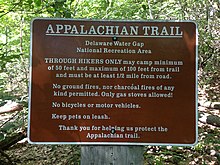
"Purists" are hikers who stick to the official AT trail, follow the white blazes, except for side trips to shelters and camp sites.
[110] The section that runs just below the summit of Kuwohi in Great Smoky Mountains National Park is along the North Carolina and Tennessee state line and is the highest point on the trail at 6,643 feet (2,025 m).
[112] Substantial portions of the trail closely parallel Skyline Drive in Shenandoah National Park and, further south, the Blue Ridge Parkway.
[114] A CSX train derailment on December 21, 2019, damaged the pedestrian footbridge over the Potomac River at Harpers Ferry, severing the trail between West Virginia and Maryland.
A portion of this section was paved by 700 volunteers with 800 granite-slab steps followed by over a mile of walkway supported by stone crib walls with boulders lining the path.
The trail proceeds northward through the Housatonic River valley and hills to its west, veering northwesterly and, at Salisbury, ascending the southern Taconic mountains, at Lion's Head affording a view northeasterly towards Mt.
Just north of Bear, the trail, as it crosses into Massachusetts, descends into Sages Ravine, a deep gorge in the eastern Taconic ridgeline which is home to a fragile old growth forest.
It summits the highest peak in the southern Taconic Range, Mount Everett (2,604 feet (794 m)), then descends to the Housatonic River valley and skirts the town of Great Barrington.
The threat of severe and cold conditions in the Presidentials and across the New Hampshire Section is present year-round and requires hikers' careful attention to weather forecasts and planning, provisions and gear.
[130] The western section includes a mile-long (1.6 km) stretch of boulders, some of which hikers must pass under, at Mahoosuc Notch, sometimes called the trail's hardest mile.
"[109] Beginning in 2007, various organizations, including the Appalachian Trail Conservancy and the American Hiking Society, began a study to monitor environmental changes that have resulted from higher ozone levels, acid rain, smog, and other air quality factors.