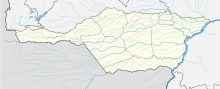
Apure
[citation needed] The conquest of Apure began in the mid 17th century when the land was populated by many indigenous peoples, including the Arawak and the Caribs.
Originating in the Tertiary (Neogene) and Quaternary (Pleistocene) periods, the Llanos (plains) of Apure are formed by sediments of little or no consolidation, with sandy and clayey deposits built up by floods in recent times.
On the banks of the Orinoco one finds outcroppings of rocks, from the Archean era, which are part of the Guiana Shield and appear at heights called galleys.
Some of these dunes are used by llaneros to establish dairy farms, which, in addition to processing milk, prepare a group of cattle to go to the head of the pack (which in the llanos is referred to as the godmother of the herd), according to the work of Calzadilla Valdés.
It is not, as noted in the Atlas of Venezuela: A Spatial Image (Atlas de Venezuela: Una imagen espacial, also known as El Atlas de Petróleos de Venezuela), an ecosystem of "paleodunas", literally 'old dunes,' formed in an environment with a much drier climate than the current one, but a mechanism of dune formation that acts only in the dry season since the lowering of the water level of the Orinoco at the rivers' lowest point, especially that of those that originate in the llanos, extensive beaches of fine sand are left behind, that the trade winds very quickly will transfer to the southeast, forming what now constitutes el Parque Nacional Santos Luzardo (the Santos Luzardo National Park), which takes its name from one of the main characters in the novel Doña Bárbara by Rómulo Gallegos.
Protruding between them are zones of dunes, delta plains, and such features as shoals, banks, and estuaries, which are very prone to floods during the rainy season.
Furthermore, in the west of the territory, one finds foothills and mountains with altitudes of greater than 3 km, in a portion of the Cordillera Oriental Andina (Eastern Andean Range) that borders Estado Táchira.
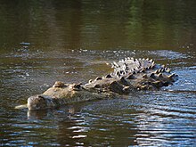
The Apure River, the most important of these, is at the same time the main Venezuelan tributary of the Orinoco from its left border, and the second longest in the country: it covers some 1,000 km (620 mi) from its source to its mouth.
The most important rivers in the state are: the Apure for which the state is named; the Arauca, at more than 700 km (430 mi) long, which has its source in Colombia and forms the border between the two countries for a stretch, and unites the Apure by means of various branches and springs before flowing into the Orinoco; the Orichuna Channel at more than 500 km (310 mi) long; the Capanaparo, Cinaruco, Cunaviche, Matiyure, and Meta.
From the Andean foothills, temperatures will decrease in proportion to the increase in altitude, reaching up to 10 °C in the extreme northwest of the state, above 3,200 meters above sea level in El Tamá.
The shape of the precipitation distribution in the Apure state is one of the fundamental characteristics, being related to modifying factors such as latitude, relief, cold fronts and intertropical convergence.
Extensive empty or almost uninhabited areas characterize its territory, traditionally affected by a strong emigration towards Aragua and the city of Caracas; nevertheless, the negative balance thrown by that phenomenon has been reverted when receiving an important flow of immigrants from the Venezuelan Andes and Colombia.
Its main towns are Achaguas, Biruaca, Bruzual, Mantecal, El Amparo, Elorza, La Victoria, Puerto Paez and San Juan de Payara.
[citation needed] According to the 2011 Census, the racial composition of the population was:[2] Agriculture and livestock are the main economic activities in Apure State.