Arabian Sea
The countries with coastlines on the Arabian Sea are Yemen, Oman, Pakistan, Iran, India and the Maldives.
The De Covilhao Trough, named after the 15th century Portuguese explorer Pero de Covilhăo, reaches depths of 4,400 metres (14,436 ft) and separates the Indus Fan region from the Oman Abyssal Plain, which eventually leads to the Gulf of Oman.
The northern sections of the Carlsberg Ridge flank the southern edge of the Arabian Basin.
The trough, reaching depths over 5,360 metres (17,585 ft), traverses the Gulf of Aden and the Arabian Sea.
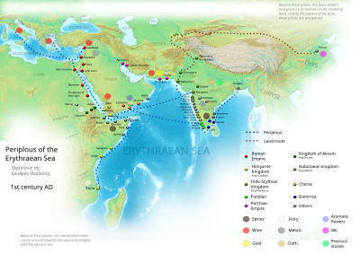
By the time of Julius Caesar, several well-established combined land-sea trade routes depended upon water transport through the sea around the rough inland terrain features to its north.
These routes usually began in the Far East or down river from Madhya Pradesh, India with transshipment via historic Bharuch (Bharakuccha), traversed past the inhospitable coast of modern-day Iran, then split around Hadhramaut, Yemen into two streams north into the Gulf of Aden and thence into the Levant, or south into Alexandria via Red Sea ports such as Axum.
Each major route involved transhipping to pack animal caravan, travel through desert country and risk of bandits and extortionate tolls by local potentates.
This southern coastal route past the rough country in the southern Arabian Peninsula was significant, and the Egyptian Pharaohs built several shallow canals to service the trade, one more or less along the route of today's Suez Canal, and another from the Red Sea to the Nile River, both shallow works that were swallowed up by huge sand storms in antiquity.
Later the kingdom of Axum arose in Ethiopia to rule a mercantile empire rooted in the trade with Europe via Alexandria.
[22][23] The Port of Karachi, Pakistan's largest and busiest seaport lies on the coast of the sea.
The Gwadar Port of Pakistan is a warm-water, deep-sea port situated at Gwadar in Balochistan at the apex of the Arabian Sea and at the entrance of the Persian Gulf, about 460 km west of Karachi and approximately 75 km (47 mi) east of Pakistan's border with Iran.
The port is located on the eastern bay of a natural hammerhead-shaped peninsula jutting out into the Arabian Sea from the coastline.
The islands form the smallest union territory of India with their total surface area being just 32 km2 (12 sq mi).
[27] Causes of the OMZ may include untreated sewage as well as high temperatures on the Indian subcontinent, which increase winds blowing towards India, bringing up nutrients and reducing oxygen in the Arabian Sea's waters.