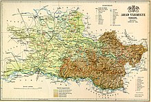
Arad County (former)

[4][5] Archaeological finds also shows that Hungarians settled in the plains along the river after their arrival in the Carpathian Basin at the end of the 9th century.

[9][10] The Maros formed the northern border of Ajtony's realm, according to the Gesta Hungarorum, but the longer version of the Legend of Saint Gerard wrote that he controlled the lands as far as the Körös River.

[12] According to a scholarly theory, first proposed by historian György Györffy, Stephen I established Arad County after Ajtony's fall.

[13] At an assembly held in Arad in 1131, the wife of King Béla the Blind, Helena of Rascia, ordered the massacre of 68 Hungarian lords.

[2][7] The first known ispán, or head, of Arad County, Paul Csanád, was mentioned in a royal diploma, dated to 1214, but its authenticity is suspect.

[16] Members of the Csanád, Csák and Dorozsma clans received estates in Arad County in the early 13th century.

[16] Solymos Castle (in present-day Șoimoș in Lipova), the first fortress built by a nobleman in the county, was erected after the withdrawal of the Mongols.

[16] Ecclesiastic institutions, prelates and lay lords – including the bishop of Csanád, the Arad Chapter and the Garais, Lackfis and Telegdis – held most former royal estates in the first half of the 14th century.

[18] The earliest Romanian place name in the county – Caprewar (now Căprioara) – was recorded in a list of the estates of the Telegdis which was completed in 1337.

Map of Arad county in the Kingdom of Hungary
Map of Arad, 1891.
Arad County in the 14th century
Csanád, Arad and Torontál counties after the Treaty of Trianon. In 1923, the three counties were merged to form Csanád-Arad-Torontál County.
Ethnic map of the county with data of the 1910 census (see the key in the description).
Clickable map of the Grand Duchy of Transylvania Kingdom of Hungary counties(clickable map) România Clickable map of the Banat County Page 21-27: Orosháza Page 21-29: Palota Page 21-30: Nădlac, Palota Page 21-31: Şeitin Page 22-28: Empty Page 22-29: Empty Page 22-30: Battonya, Pecica Page 22-31: Pecica Page 22-32: Semlac Page 23-27: Gyula, 	Pilu, Vărşand Page 23-28: Aletea, Grăniceri, Kétegyháza, Şiclău Page 23-29: Macea Page 23-30: Curtici Page 23-31: Arad Page 23-32: Bodorok Page 24-27: Avram Iancu, Mişca, Zerind Page 24-28: Chişineu-Criş, Olari, Sintea Mare, Socodor Page 24-29: Olari, Sântana, Şimand, Zărand Page 24-30: Sântana, Şiria Page 24-31: Covăsânţ, Ghioroc, Păuliş, Vladimirescu Page 24-32: Păuliş, Vladimirescu Page 25-25: Batăr Page 25-26: Apateu, Mişca, Şepreuş Page 25-27: Cermei, Şicula Page 25-28: Ineu, Pâncota, Seleuş, Şicula, Târnova, Zărand Page 25-29: Almaş, Pâncota, Şiria, Târnova Page 25-30: Păuliş Page 25-31: Conop, Lipova Page 26-25: Căpâlna, Cociuba Mare, Olcea, Pocola, Şoimi, Tinca Page 26-26: Craiva, Hăşmaş, Lunca, Olcea, Şoimi Page 26-27: Archiş, Cărand, Beliu, Hăşmaş, Târnova Page 26-28: Bârsa, Bocsig, Seleuş, Şilindia Page 26-29: Chisindia, Şilindia, Târnova, Tauţ Page 26-30: Bârzava Page 26-31: Conop, Bârzava Page 27-25: Archiş, Dezna, Igneşti, Moneasa, Sebiş Page 27-26: Bârzava, Buteni, Craiva, Dezna, Dieci, Igneşti,Moneasa,  Sebiş Page 27-27: Almaş, Bârsa, Bârzava, Brazii, Chisindia, Dieci, Gurahonţ, Sârbi Page 27-28: Bârzava, Vărădia de Mureş Page 27-29: Bârzava, Lupeşti, Săvârşin, Vărădia de Mureş Page 27-30: Vărădia de Mureş Page 28-25: Cărpinet, Câmpani, Criştioru de Jos, Lunca, Ştei, Vaşcău Page 28-26: Cărpinet, Dezna, Dieci, Gurahonţ, Page 28-27: Brazii, Gurahonţ Page 28-28: Petriş, Săvârşin Page 28-29: Petriş, Săvârşin Page 28-30: Săvârşin RO/HU/DE/Legend Clickable map of the Bihor Conty Original map of the Kingdom of Hungary
Josephinische Landesaufnahme . Senzitive map of the Arad county, 1782-1785. (Click on the desired quadrant)