Arctic Ocean
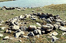
The Dorset were the last major Paleo-Eskimo culture in the Arctic before the migration east from present-day Alaska of the Thule people, ancestors of the modern Inuit.
[9] The Thule Tradition lasted from about 200 BC to AD 1600, arising around the Bering Strait and later encompassing almost the entire Arctic region of North America.
The Thule people were the ancestors of the Inuit, who now live in Alaska, Northwest Territories, Nunavut, Nunavik (northern Quebec), Labrador and Greenland.
Pytheas of Massilia recorded an account of a journey northward in 325 BC, to a land he called "Eschate Thule", where the Sun only set for three hours each day and the water was replaced by a congealed substance "on which one can neither walk nor sail".
He was probably describing loose sea ice known today as "growlers" or "bergy bits"; his "Thule" was probably Norway, though the Faroe Islands or Shetland have also been suggested.
The few expeditions to penetrate much beyond the Arctic Circle in that era added only small islands, such as Novaya Zemlya (11th century) and Spitzbergen (1596), though, since these were often surrounded by pack-ice, their northern limits were not so clear.
The makers of navigational charts, more conservative than some of the more fanciful cartographers, tended to leave the region blank, with only fragments of known coastline sketched in.
In the United States in the 1850s and 1860s, the explorers Elisha Kane and Isaac Israel Hayes both claimed to have seen part of this elusive body of water.
The first surface crossing of the ocean was led by Wally Herbert in 1969, in a dog sled expedition from Alaska to Svalbard, with air support.
[13] In World War II, the European region of the Arctic Ocean was heavily contested: the Allied commitment to resupply the Soviet Union via its northern ports was opposed by German naval and air forces.
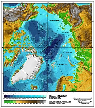
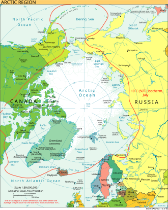
The Arctic Ocean is surrounded by the land masses of Eurasia (Russia and Norway), North America (Canada and the U.S. state of Alaska), Greenland, and Iceland.
During the Cretaceous period, the Canadian Basin opened, and tectonic activity due to the assembly of Alaska caused hydrocarbons to migrate toward what is now Prudhoe Bay.
Throughout the Cenozoic Era, the subduction of the Pacific plate, the collision of India with Eurasia, and the continued opening of the North Atlantic created new hydrocarbon traps.
The Arctic Coring Expedition drilling shed some light on the Lomonosov Ridge, which appears to be continental crust separated from the Barents-Kara Shelf in the Paleocene and then starved of sediment.
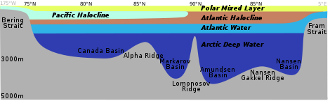
It resembles some hydrological features of the Mediterranean Sea, referring to its deep waters having only limited communication through the Fram Strait with the Atlantic Basin, "where the circulation is dominated by thermohaline forcing".
Water in the shelf region that begins as inflow from the Pacific passes through the narrow Bering Strait at an average rate of 0.8 Sverdrups and reaches the Chukchi Sea.
[37] During the winter, cold Alaskan winds blow over the Chukchi Sea, freezing the surface water and pushing this newly formed ice out to the Pacific.
[36] This process leaves dense, salty waters in the sea that sink over the continental shelf into the western Arctic Ocean and create a halocline.
Inflow from the North Atlantic Current enters through the Fram Strait, cooling and sinking to form the deepest layer of the halocline, where it circles the Arctic Basin counter-clockwise.
[46] Waters originating in the Pacific and Atlantic both exit through the Fram Strait between Greenland and Svalbard Island, which is about 2,700 m (8,900 ft) deep and 350 km (220 mi) wide.
[35] Pacific water also exits along the west coast of Greenland and the Hudson Strait (1–2 Sv), providing nutrients to the Canadian Archipelago.
In addition, there is a sea level pressure (SLP) ridge over Greenland that drives strong northerly winds through the Fram Strait, facilitating ice export.
During the Paleocene–Eocene Thermal Maximum 55 million years ago, when the global climate underwent a warming of approximately 5–8 °C (9–14 °F), the region reached an average annual temperature of 10–20 °C (50–68 °F).
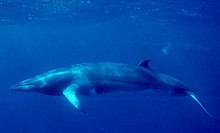
Petroleum and natural gas fields, placer deposits, polymetallic nodules, sand and gravel aggregates, fish, seals and whales can all be found in abundance in the region.
[29][51] The political dead zone near the centre of the sea is also the focus of a mounting dispute between the United States, Russia, Canada, Norway, and Denmark.
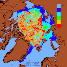
[69] Reduction of the area of Arctic sea ice reduces the planet's average albedo, possibly resulting in global warming in a positive feedback mechanism.
[73] Warming temperatures in the Arctic may cause large amounts of fresh melt-water to enter the north Atlantic, possibly disrupting global ocean current patterns.
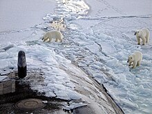
[75] Beginning in December 2018 and coming to an apex in February 2019, a mass invasion of polar bears into the archipelago of Novaya Zemlya caused local authorities to declare a state of emergency.
Melting of this ice may release large quantities of methane, a powerful greenhouse gas, into the atmosphere, causing further warming in a strong positive feedback cycle and marine genera and species to become extinct.
[83] On 16 July 2015, five nations (United States, Russia, Canada, Norway, Denmark/Greenland) signed a declaration committing to keep their fishing vessels out of a 1.1 million square mile zone in the central Arctic Ocean near the North Pole.