Topography
Topography is a field of geoscience and planetary science and is concerned with local detail in general, including not only relief, but also natural, artificial, and cultural features such as roads, land boundaries, and buildings.
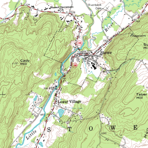
[1] In the United States, topography often means specifically relief, even though the USGS topographic maps record not just elevation contours, but also roads, populated places, structures, land boundaries, and so on.
[2] Topography in a narrow sense involves the recording of relief or terrain, the three-dimensional quality of the surface, and the identification of specific landforms; this is also known as geomorphometry.
An objective of topography is to determine the position of any feature or more generally any point in terms of both a horizontal coordinate system such as latitude, longitude, and altitude.
A topographic study may be made for a variety of reasons: military planning and geological exploration have been primary motivators to start survey programs, but detailed information about terrain and surface features is essential for the planning and construction of any major civil engineering, public works, or reclamation projects.
Which method(s) to use depends on the scale and size of the area under study, its accessibility, and the quality of existing surveys.
This data must often be "cleaned" to eliminate discrepancies between surveys, but it still forms a valuable set of information for large-scale analysis.
False-color and non-visible spectra imaging can also help determine the lie of the land by delineating vegetation and other land-use information more clearly.
More sophisticated algorithms can exploit other information on the scene known a priori (for example, symmetries in certain cases allowing the rebuilding of three-dimensional co-ordinates starting from one only position of the camera).
In recent years, LIDAR (LIght Detection And Ranging), a remote sensing technique that uses a laser instead of radio waves, has increasingly been employed for complex mapping needs such as charting canopies and monitoring glaciers.
In civil engineering and entertainment businesses, the most representations of land surface employ some variant of TIN models.
In practice, surveyors first sample heights in an area, then use these to produce a Digital Land Surface Model in the form of a TIN.
While of historical interest, these field notes inherently include errors and contradictions that later stages in map production resolve.
These maps show not only the contours, but also any significant streams or other bodies of water, forest cover, built-up areas or individual buildings (depending on scale), and other features and points of interest.
Digital Elevation Models, for example, have often been created not from new remote sensing data but from existing paper topographic maps.
Topological relationships between geometric entities traditionally include adjacency (what adjoins what), containment (what encloses what), and proximity (how close something is to something else).