Argyll
Six towns in the county held burgh status: Campbeltown, Dunoon, Inveraray, Lochgilphead, Oban, and Tobermory.
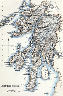
Argyll borders Inverness-shire to the north, Perthshire and Dunbartonshire to the east, and (separated by the Firth of Clyde) neighbours Renfrewshire and Ayrshire to the south-east, and the County of Bute to the south.
The district created in 1975 excluded the Morvern and Ardnamurchan areas from the pre-1975 county, which were transferred to the Highland region, but included the Isle of Bute, which had not been in Argyll.
Further reforms in 1996 abolished the Strathclyde region and made Argyll and Bute a single-tier council area instead.
[5] The Kilmartin Glen has standing stones and other monuments dating back to around 3000 BC, and is one of the most significant areas for Neolithic and Bronze Age remains in mainland Scotland.
A fortress at Dunadd in the Kilmartin Glen, 4 miles (6.4 km) north-west of the modern town of Lochgilphead, served as the main seat of the kingdom.
[9] The name Argyll (Airer Goídel), meaning 'coast or borderland of the Gaels', came to be used for the part of the former Dál Riata territory on mainland Britain.
The name distinguished the area from the Innse Gall, meaning 'islands of the foreigners' which was used for the Kingdom of the Isles, ruled by Old Norse-speaking Norse–Gaels.
It was called North Argyll as it was settled by missionaries and refugees from Dál Riata, based at the abbey of Applecross.
At the start of the 17th century, under instruction from James VI, the Campbells were sent to the MacDonald territory at Islay and Jura, which they subdued and added to the shire of Argyll.
[17] In 1667, Commissioners of Supply were established for each shire, which would serve as the main administrative body for the area until the creation of county councils in 1890.
In 1746, following Jacobite insurrections, the Heritable Jurisdictions Act abolished regality, and forbade the position of sheriff from being inherited.
[20][21] Argyll was abolished as a county for local government purposes in 1975, with its area being split between Highland and Strathclyde Regions.
The Ardnamurchan, Ardgour, Ballachulish, Duror, Glencoe, Kinlochleven, and Morvern areas of Argyll were detached to become parts of Lochaber District, in Highland.
In 1996, a new unitary council area of Argyll and Bute was created, with a change in boundaries to include part of the former Strathclyde district of Dumbarton.
[33][34] Argyll is split into two non-contiguous mainland sections divided by Loch Linnhe, plus a large number of islands that fall within the Inner Hebrides.
Mainland Argyll is characterised by mountainous Highland scenery interspersed with hundreds of lochs, with a heavily indented coastline containing numerous small offshore islands.
This area, in the vicinity of Fort William and along the railway line, contains the largest towns of northern mainland Argyll.
The topography of south Argyll is in general heavily mountainous and sparsely populated, with numerous lochs; Kintyre is slightly flatter though still hilly.
Near Glen Coe can be found Bidean nam Bian, the tallest peak in the county at 1,150 m (3,770 ft).
As their areas have been largely unchanged since the 19th century, this allows for comparison of population figures over an extended period of time.
The West Highland railway runs through the far north of the county, stopping at Locheilside, Loch Eil Outward Bound, Corpach and Banavie, before carrying on to Mallaig in Inverness-shire.
A branch of the line also goes to Oban, calling at Dalmally, Loch Awe, Falls of Cruachan, Taynuilt and Connel Ferry.
[42] The county contains a number of small airports which serve the region and Edinburgh/Glasgow: Oban, Tiree, Coll, Colonsay, Campbeltown and Islay.